After my last post about hill lists time for a report based on its inspiration. I was missing just one Nuttall from South Wales so time to bag it. The Forecast wasn’t much better than the dreadful day above Cwmbran the day before but I woke to blue skies so I headed out.
Parking up in Llangynidr things were much better than yesterday. Abundant blue skies and even a hint of snow high up. Normally a positive but not when you weren’t expecting it and had trail shoes on! The views through the village and out in the fields were gorgeous if a little chilly in a cold wind.
My planned route was a long circuit around the Dyffryn Crawnon Valley to pick up my missing Nuttall of Cefn Yr Ystrad, a high point in the middle of nowhere just south of the Beacons.
The walk up through the fields to the access land was rather pleasant and less muddy than I’d thought.
Looking back towards the Black Mountains.
It was a long steady climb through the bracken until I reached the grassier slopes of the limestone plateau. It was great walking here on cropped grassy paths and a fine spot for a wild camp.
As I reached the quarry road a snow shower hit me, quite a nasty one. Not sure on the official duration of a “shower” but this one lasted about two hours!
I enjoy walking through quarry landscapes. The have lots of false edges, ridges and deep holes with lakes. This one came out of nowhere as I thought I was heading into the hills behind I crested a slope to find it. Took quite a walk to get around it.
Distant blue skies while it continued snowing on me.
The benefit of OS Maps on my phone came to the fore when looking for the summit in the mist and snow. Its a fairly vague expanse of small knolls and bumps and pretty sure I’d never have found it without the software such is the confusing terrain created by the quarries. Not the most inspiring summit but it was nice to climb it in winter conditions.
Continuing my route took quite a walk to get safely around the quarries. As I dropped around the back to the path it stopped snowing and the sun came out.
Nothing better than walking in a snowy landscape in the sunshine although it was bitterly cold.
Heading back down the other side of the valley, the Talybont reservoir came into view. I needed to stop for a late lunch but it windy and pretty wet everywhere. Lunch stops were not forthcoming.
Still, the views were magnificent.
Eventually I found a dryish and sheltered spot for a sit down although it was raining. Just as I thought better of it, it stopped and the sun came out again.
The views were sensational. Gorgeous browns of the bracken and the white caps on the Brecon Beacons.
I’d planned on finishing off the route with the hill of Tor y Foel but it was getting late and I was pretty knackered (drawing in the route I discovered it was 16 miles!)
I headed off down the Beacons Way back to Llangynidr.
Some nice sunny views along the valley but the path was a sloppy mess. As soon as I hit the road I decided I’d had enough mud for one day and followed the road back to village and the car.
After the previous day’s soaking this was a superb day. A new hill, some exploration of wild and weird terrain and a real feeling of winter.
In the past 12 months or so I’ve rekindled my interest in hill lists. Not in an attempt at completing any, more out of curiosity and an effort to use them to discover walks I might never have been on. I’ve had some mixed results, mostly I found some pretty decent new spots with a few that whilst diverting, not places I ache to go back to. These photos are from one of the latter walks so I thought I’d pad things out with some words on what I’ve come to find a fascinating topic.
When I started my hiking journey back in my university days the list of the day was Scottish Munros. We were all pretty obsessive and between 1984 and 1998 I managed to pick up 200 (my first munro was Rudh Stac Mhor on Beinn Eighe and my 200th Ben Lomond in case you’re interested). Since then after moving too far south for regular trips to the Highlands that pace has slowed dramatically such that my grand total is still only 213 over 20 years later (although they took two off me in the last revision). I hope to complete them sometime before I shuffle off although I’ll need some help with the Skye ridge (where I’ve only done a few of the easier ones) and a whole heap of fuel and passion for walking in rain and bog!
The other big Scottish group are Corbetts. Only 55 of 222 for me due to the fact they are harder to tick off. The rule around what constitutes a Corbett is much tougher and strictly applied so they tend to be isolated such that more than one in a day is a big ask. Chances of completing them are zero not least because some are seriously dreary and uninteresting.
The recent obsession was with Marilyns (any hill with 150m drop on all sides, strictly applied). How to find them was the challenge as there are quite a few, 1622 in fact in the UK. I discovered the well known Hill Lists App and it was a couple of quid well spent. Its devoured a good deal of my life recently as I populate with data from my memory banks and in poking around looking for new places to go.
It was the reason that this walk found its way into my life. Its Mynydd Twyn Glas, just above Cwmbran in the Welsh Valley’s. The forecast looked ok, sunshine and showers but the latter was the end result. This may be fine hill on a fine day but in ceaseless, cold rain it was a dreary and cheerless experience. Still another one ticked off I guess.
Long way to go though. I’ve only done 59 of the 158 in Wales, 68 of 175 in England and a paltry 227 of 1219 in Scotland. I suspect that completing the list is a big ask. Not because I’m not a keen hiker you understand, but some of them are seriously obscure and many are on private land and need some discrete trespassing. Worse there are some sea stacks in the list and some on St Kilda, not exactly easy to get to!
I’ve also been poking around with other lists. Wainwrights are an obvious one and I’m at a respectable 143 out of 214. A few days in the eastern fells around Shap and I wouldn’t be far off completing them. I exclude the Outlying Fells as there are some seriously obscure ones in there.
Nuttalls was the only other one on the lists I recognised (England & Wales summits over 2000 feet with 15m drop all round). My proudest achievement is in here as I’ve completed all the South Wales ones. Sadly, not that much of an achievement really seeing as I live in the neighbourhood and only completed them on my next walk to post up but the map in the app looks good! I’ve done 113 of 189 in Wales (so plenty left in North Wales to get my teeth into) and 113 of 189 in England.
Humps are the other that fascinate me. Basically Marilyns but with only 100m drop (name stands for Hundred Metre Prominence). There are bloody thousands of them even more obscure and remote, 3100 to be precise of which I’ve done only 489, less than 20%. I might really struggle to complete these! Still nearly 500 summits of various heights and dimensions is not a bad reward for 35+ years of hill obsession.
I’ve found it endlessly enjoyable and fascinating filling in the stats, looking at maps, trying to remember which one’s I’ve climbed and when, what route we took and which other insignificant (at the time) bumps and tops I’ve been over and can tick off. I’ve not become obsessed or anything, honest!
The Hill lists App is well worth a couple of quid of any obsessive outdoor types money considering the effort the creator goes to produce and update it and its very easy to use. It has a whole load of lists I’ve never heard of if you are so inclined (Archies anyone) and has a direct hook into MWIS which is very handy. You can backup and export between devices so you always have an up to date copy somewhere.
Hope you enjoyed my little reverie into hiking by statistic. Pictures of a proper long hike in the snow (with a new Marilyn/Hump/Nuttall summit thrown in) in the next post.
Footnote 1: I’m doing well in the TGO 40 best UK mountains list, only 4 left!
Footnote 2: All stats subject to a margin of error due to poor memory going back 35+ years!
All good things come to an end and so does cold winter weather. After four days of back to back sunshine, wet, windy and miserable weather was to the fore and opportunities to step outside were minimal.
Watching rain streak the windows and flood the roads has been the theme ever since mid January. The lower fields are swamped with water and mud. The higher fells often out of bounds due to the high winds.
One of the short interludes gave me and TBF a chance for a walk and Bryn Arw is perfect. Most of the low level walking is on roads and farm tracks and its not high enough to be wind blasted.
Picking our moment between heavy showers we dashed beside, up, along and down the mountain in an hour or so.
A walk that always delivers and as yet I’ve never seen anyone on the summit ridge even though I’ve been up here many times.
We even saw the sun for the briefest of moments on the way down. Small pleasures.
Another late afternoon dash after a job interview and a very nice lunch with a good mate from my previous role. As ever with a late start, a high summit with a high starting point was needed and the Sugar Loaf always fits that bill very nicely.
I followed my classic route around to the ridge of Mynydd Pen y Fal.
Late afternoon sun working its light magic on the Bracken.
There were banks of clouds building, a sign that the good weather of the past few days was coming to an end. Rain and winds were set to return.
It was a brisk walk as I could see the sun sinking towards the clouds and horizon and wanted to be on top for sunset.
The clouds created some wonderful light effects as I reached the summit. As it was a weekday afternoon I only saw a handful of people on what is normally a very busy mountain.
The summit rocks provided their usual excellent foreground for great photos.
As does the Trig Pillar, catching the pink late afternoon sunlight.
The gathering clouds out to the west began to look more and more ominous. I was glad I’d made the effort to catch one more sunny walk before it came crashing/washing down.
The walk down gave some nice sunset images as the sun passed through and peeped out of the cloud bank.
And a final shot of a surreal looking colour to the bracken as I reached the car.
Back to normal from there with the rest of the week a long sequence of grey days and heavy rain. I enjoyed the sunshine while I could.
After two straight, long days out in the hills, domestic chores intervened. Another gorgeous sunny day spent putting my daughters new bed together. There was just time for a sneaky walk. Not until I’d negotiated B&Q, school traffic and a visit to the waste site that was closed.
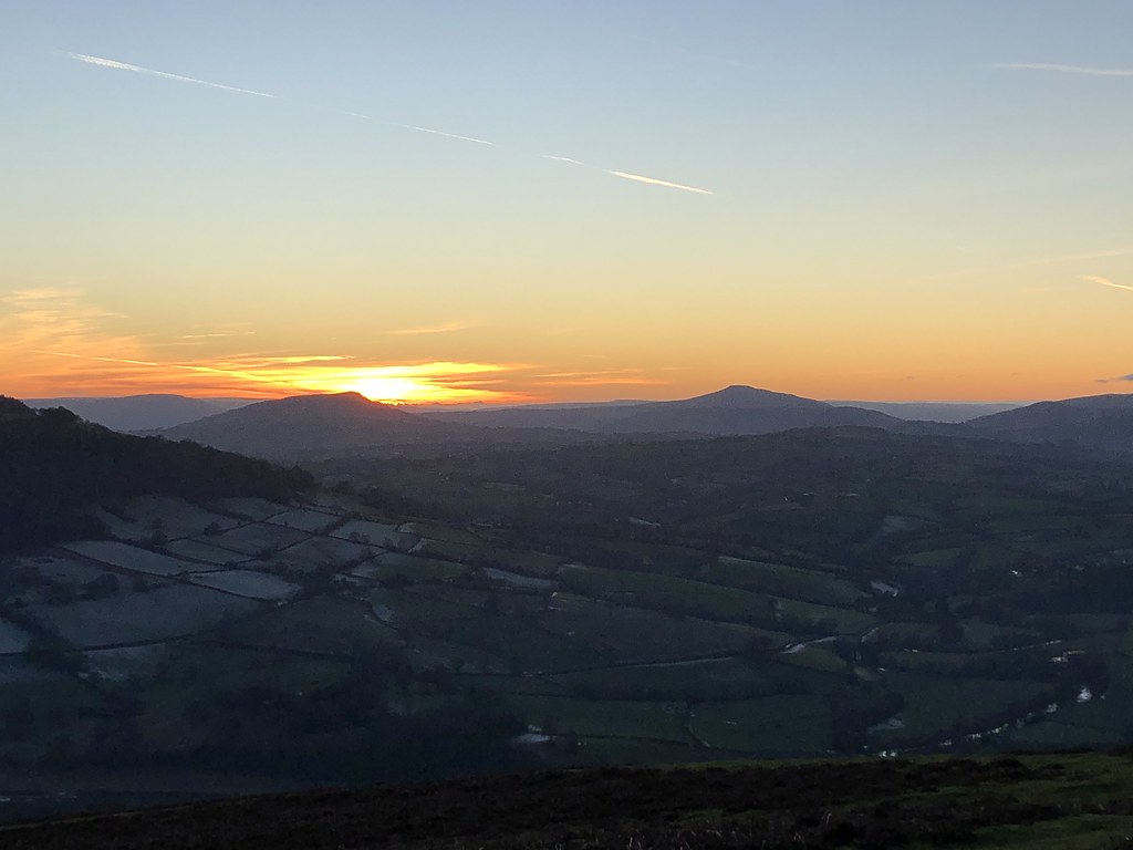
I’d plumped for Garway Hill as you can drive pretty much to the top but even that road was blocked by a guy loading up his car! The fates were conspiring against me.
I pretty much ran up to the top as I didn’t want to miss the sunset. The setting sun was working its magic on the bracken.
I made the top just in time so see the sun set behind the Black Mountains. There were a few people up there with the same idea.
It was mighty cold but well worth the mad dash along frozen lanes in the car and frozen paths on foot.
I should have thought to bring my stove and brew up to watch the show but I’d probably have missed the sunset altogether if I had.
I settled for a brief 45 min wander around before it got too dark to follow the paths.
As always, the bare gnarly trees caught my eye.
A day of domestic drudgery rescued by a mad dash to a local summit.
Back to back sunny days have been a rarity this winter so when they arrive you have take advantage. Even after the previous days long outing in the Beacons, with a forecast this good, I’d normally be out at the crack of dawn and heading for the big Snowdonia ranges. However a need to ferry TJF to and from work curtailed that plan somewhat. I plumped for a Shropshire walk and the need for peaks with expansive views seemed in order so I headed back to what I refer to as the Churchstoke Hills
A stunning day. After a brief spell negotiating soggy fields and cows (and their churned aftermath), I was on the open access land of Todleth Hill.
Its a superb spot and the lack of obvious paths seems to indicate it sees very few visitors.
I had it to myself and the views across towards the Welsh Mountains were crystal clear.
Across to the Shropshire Hills, Long Mynd and Stiperstones
As was my next objective, Roundton Hill.
One of this hills that only discovered when idly looking at maps for somewhere to walk. Its a cracker of a small hill, albeit brutally steep from the direction I was tackling it. I plunged down into the chilly depths of the nature reserve before warming up on the very steep climb to its summit.
Breathtaking views awaited. Back to Todleth Hill.
Corndon Hill, next on my list.
Stiperstones
And a panorama to capture the essence. I could see all the major Snowdonia ranges. Cadair Idris, Arans, Berwyns and even Snowdon (although I would never have guessed had it not been for the toposcope on the summit).
I sat and scoffed a chocolate bar for energy – I felt I needed some as I watched competitors running an orienteering race.
Onwards to Corndon Hill, finding a much better green path than the heather bashing of my previous visit. The views were sensational especially over to the bristling rocky spine of Stiperstones. I’d spotted the perfect lunch stop by these rocks but a couple of mountain bikers beat me to it.
I settled for the short walk to the summit to satisfy my food and brew craving.
My next objective, Lan Fawr.
Nothing beats the peace and quiet of a fresh brew on a lonely summit on a clear sunny winters day.
Lan Fawr has no paths but like Todleth Hill its easy walking on grassy hills in access land.
Its perched on the edge of this range so the view over the hills of mid-Wales is breathtaking.
I found time for another rest sat on this grassy knoll. I should point out that when I said easy walking this did entail some extraordinarily slippery grass with a coating of what looked like aloe vera hand gel – at least that’s what it looked and felt like when I put my hands in it on an impromptu tumble.
The path towards Churchstoke from here is a simple delight, grassy, with great views enhanced by the wild and twisted trees.
What little cloud there had been was now gone bathing the hills with a gorgeous winter glow. I was very happy.
Such was my happiness I decided on a second ascent of Todleth Hill (rather than take on an extended stretch of likely muddy fields back to the car).
The views from the top were even better than the morning now the sun was in position to light up Corndon and Roundton Hills.
I was happy. I think this is my natural look of concern that I will either cock up the selfie or that I will look a bit crap. Oh well.
I love to watch the setting sun, although this one was chillier than recent and without a beer.
A final brew of tea and more snacks was more than sufficient.
Reluctantly I headed down as the skies turned darker.
Not precisely the route I followed )doesn’t include my repeat of Todleth Hill) but close enough.
In the end I was glad the routine had dictated a shorter drive and a different walk. I was able to take things easy, at a leisurely pace and with many stops to ensure this day of sunshine was not wasted. After my comments in the last post, it seemed entirely appropriate.
Finally, clear blue skies, sunshine and frost! Well back in late January anyway.
A chance to head to the mountains for a proper day of winter walking in the Brecon Beacons. I thought I’d set off early enough for a spot in the car park in the Neuadd Valley but apparently not. I had to park on the lower car park and rather than walk along the road I followed what I hoped was a nice forest track through the woods. The views were great but the track was, like every track and path this winter, a slick mess of mud, bog and water. Again I was glad of waterproof socks – they really have been essential this winter.
Back on the steep climb to the edge of Graig Fan Ddu, water was replaced by ice and the rocky steps were a little slippery but fast progress was made despite avoiding a guy who thought it would be a good idea to cycle down an icy, rocky staircase with lots of people on it.
The views opened out and all was glorious. With the steep section done its a wonderful high level stroll on the edges towards the high summits.
I love the section where it “narrows” (these things are relative in South Wales) on the ridge of Craig Gwaun Taf.
Approaching Corn Du and Pen y Fan the crowds from the Storey Arms started to mass. Something you have to get used to up here on a sunny day.
There was a light dusting of snow on Corn Du lending the mountains more of a wintery feel and setting off the views to even better effect.
Looking back the way I’d come.
On Pen y Fan I began to realise why the car park was full. There was yet another challenge walk of some kind in progress. I have to say I really don’t get the recent obsession with these things. To me, the mountains are there to be savoured and enjoyed, an escape from the pressures of life and work.
It seems that these walks simply replace one kind of stress with another. Looking at all these people climbing to the summit, almost every one looked unhappy and simply trudging on, not stopping on the summit to enjoy the panorama on a wonderful day. You hear increasing stories of problems both on the walk and around the start/end points. People not understanding the rigours and discipline required to undertake these walks and how to thrive and survive. And they fill up my car park spot! 🙂
I also noted the route they were taking wasn’t going over Cribyn. Another failing of such walks is they often miss the best bits. Cribyn is one of the highlights of the Brecon Beacons and a far better summit than Pen y Fan. Its just not the highest point you see. Their loss and my gain as there was only a handful of people on the summit which I chose for a long stop and a brew.
It was such a fine day that it was an easy decision to climb Fan y Big as well. Another high quality summit that sees a a fraction of the people that Pen y Fan does.
The wander along its southern ridge in winter is a delight as the low angle picks out the features and small patches of water.
The classic view along the northern escarpment of the Beacons.
The continuation of that escarpment is one of the best sections but I was running short on time so I cut the corner off back towards the edge of Craig y Fan Ddu.
Its a soggy section but there is small rocky outcrop in the middle with super views to the South. Time for another sit down and take in the late afternoon ambience.
Edges with deep valleys beneath is the order of the day in the Beacons and swapping north for south gives another perspective. This edge and valley of Caerfanell is one of my favourites as well.
This section of path perched above a steep drop is sensational and on this late evening a simple joy.
Its a steep drop down to the road and I thought I’d save myself a bit of that by cutting the corner off across to the road.
Its a horrid, lumpy and soggy path so I have no idea why I did it again. It was worse than before, even wetter and with the sun so low that my head was staring straight into it while my feet were in dark shadow. I lurched and cursed my way back to the road. Thank goodness it saved me 3-4 minutes of walking!
A magnificent day and so good to finally see and feel something of a winter vibe.
There is a prominent hill over in Gloucestershire that’s been catching my eye over the past couple of years. It has a very obvious clump of trees on the top and is visible from pretty much every point in the eastern side of my local mountains. A little digging revealed its May Hill, just outside Newent in Gloucestershire. Another dreadful morning of heavy rain was followed with promise of a clearance ahead of a spell of proper cold and frosty winter weather so a chance to take a look.
It was lamping it down when I parked up but after a brief wait in the car it stopped and the sun came out. As you’d expect the going was slick and muddy through the woods before emerging onto the summit meadows, crowned with that small woodland that marks out this fine summit from a distance.
It’s not an area I’ve ever walked so its something of a surprise to find it here. Not exactly mountainous but its not far off a 1000 feet high. Its relatively isolated so the views are rather fine. Here looking across to the Black Mountains.
Very reminiscent of the Begwyns nearer to home with its own little summit woodland. This area seems to be the capital of long distance footpaths. At some point on this outing I walked The Wysis Way, The Geopark Way, The Gloucestershire Way and The Three Choirs Way!
I headed off down to lower reaches to make a circuit of things.
The paths through the woods gave some nice views up to the blue sky through the trees but the paths were mudslides.
The path through Newent Woods was almost impossible to find and wet beyond belief. My waterproof socks were a god-send! This small fishing lake and its access roads gave some respite from the mud on my way into the beautifully named village of Clifford’s Mesne.
From there it seemed reasonable to head back to the summit to catch some late afternoon light from the top.
A view back to the Malverns
And the spooky summit woods.
The view across the Severn Valley was immense. You could see the river snaking down towards the estuary, the sun picking it out but this photo doesn’t do it justice.
The temperature was dropping quickly and it was chilly on the summit so time to head for home. A very worthwhile outing although much better lower down in a drought!
Another day of very heavy showers and another attempt to head out when it seemed to break. I needed a short walk with a high start and possibly a new hill. Bradnor Hill above Kington was just the job.
You can park up by the Golf Course which spreads over the hill. It reaches nearly 400m and (after a bit of Internet research) is the highest 18 hole golf course in the UK (There is a 10 hole course in Alston, Cumbria that’s higher) A stunning spot for a round and despite the bitterly cold wind on this exposed patch of high ground and there were a few hardy souls playing.
I caught a very lucky break as I missed all the showers and spent the entirety of the walk in abundant sunshine. As it was midweek I hardly saw anyone save for a friendly chap and his young bouncy dog.
More expansive views across the Herefordshire countryside as I made my way along Offa’s Dyke path.
And to the Dyke itself. Not terribly impressive but nice to walk along a bit of history.
Cracking views across from Rushock Hill.
Bradnor Hill is the highest in this little corner but its not very dramatic. Slightly lower but very much more eminent is Herrock Hill. Time to pick off the summit.
I hate bracken, horrid stuff, but when its died off and catches the low winter light it does have a rather special golden glow to it.
Across to the Radnor Hills.
Hergest Ridge, Hanter Hill and Stanner Rocks.
Back to Rushock Hill.
There didn’t seem to be right of way up onto the Access Land of Bradnor Hill so I had to do a bit of subtle off piste and fence climbing to make a circuit. Some gorgeous views back to Herrock Hill as I climbed.
As you approach the higher ground it does come as surprise to find fairways and well tended greens. The actual summit marker is in the rough between two such fairways.
A stroll back across the heathland and golf course to the car. Unlike some courses, the signs seem to be very respectful of walkers and a couple of the players gave me a wave as I passed.
Another new hill ticked, more on this growing obsession in a later post.
Enough of those images of warm sunshine and smug words about sunset beers etc. On returning to the UK, I was a man of leisure. My contract had finished and I didn’t have a new one to go to. I had grand plans to walk the hills and make sure I did some form of outdoor exercise every day while I looked for a new role somewhere. The British winter weather put pay to that. The first week or so was wet and windy with several days of ceaseless rain. Trips out were limited to short bike rides between the rain and the odd walk. This first image is from one of those bike rides looking put over my local fields and hills.
Main focus of the post is from a short, wild and windy trip into the Black Mountains above Llanthony.
The Black Darren is a landslip that’s created a series of “false” ridges and valleys that make a fine walk. It’s about the shortest drive from home and only takes an hour or so, ideal for a short break between rain showers.
I scrambled the main “ridge” quite exposed and delicate in the high winds but worth it for expansive views of the pastoral Herefordshire countryside.
No place to hang around on top of the ridge, windy and cold.
I found a sunny and almost sheltered spot for a very brief sit down to admire the views.
As it’s the most easterly off the ridges of the Black Mountains you can see for miles when the air is clear like this.
What was striking was just how wet and muddy underfoot it was after what seems like endless rain this winter. It will become a theme of my next few posts!
I spend alot of my time surfing the web looking for ideas on places to go, walking routes, travel ideas and tips to plan the perfect holiday or day out. (I'm a project manager I like to plan). I thought it was time to share my own experiences and contribute to the vast amounts in information that's already out there.
I'll also add in some gear and tech reviews and when something irks me I may even use this forum to have a rant - I do that pretty well I'm told.There are a few pages at the top that give a bit of background to what I like to get up to and what you can expect to see in my posts. I'm not exactly a creative writer but I hope some people will find my stuff useful or inpsiring or at least enjoy some of my photos.