Short post from a short walk on a grey day. Grey seems to be the over-riding colour for this autumn. Probably a little unfair as my previous post was sunny and my next one will be. Probably my impression is coloured by my efforts to take outdoor exercise every day so I see a lot of grey as it were!
Bryn Arw is a favourite for this sort of outing when you need a short walk or the day just doesn’t justify a full outing.
Small, perfectly formed and with great views of the surrounding mountains.
It still surprises me that on dozens of walks up here I rarely see anyone else. I suspect everyone heads for the more popular hills of Ysgyryd Fawr and Sugar Loaf. The latter in the background here.
Distant brightness beyond the Forest of Dean, likely Avon or Somerset.
The aforementioned Ysgyryd Fawr.
The grassy path along the summit ridge is always a pleasure to walk even on a grey, cool and windy day like this one.
The highest summits of the Black Mountains.
And on our way back, a Dovecote with some real Doves resting on the roof! I don’t think I’ve ever actually seen that before
It’s been a pretty dismal autumn so far. I’ve been waiting for some cold, clear frosty weather or some days of sunshine, showers and booming clouds but its been uniformly grey and dreary ever since I went to Scotland.
Apart from one day a couple of weeks ago. We were up late as the forecast only promised some possible sunny intervals later in the day when in fact it was a stunning clear blue day, warm enough to feel like summer.
We headed out to the Radnor Hills as TBF hasn’t been there for a while. I’d also found some new paths from my last visit which I was keen to share. We parked up in New Radnor by what I thought was an elaborate war memorial but was in fact just a monument to some local nob and landowner from days of yore.
Across the fields and into Mutton Dingle.
Stunning views on a gorgeous morning.
The new paths I found took us up through forests dappled with sunlight until you emerge near Whinyard Rocks and this fabulous views over Herefordshire towards the Kington Hills and the Marches.
A steep climb to the pointy little hill of Whimble.
Whinyard Rocks and Bache Hill.
Views out to the Black Mountains and the Beacons.
Time for first lunch on the summit.
Views down towards Harley Dingle.
Onwards to Black Mixen and its attendant Transmitter.
This lone pine always catches my eye for a photo.
The route round to Great Rhos used to involve a laborious trudge around a boggy forest. That forest has now been cleared and opened up an excellent path that takes a more direct route to the top.
Great Rhos is the highest point but as you can see, highest doesn’t always equal excitement and the best views!
It’s a lonely and soggy plateau of heather and grass with paths that seems to meander about without truly heading in any particular direction. In part this is due to the fact that Harley Dingle below is a privately owned shooting range that I think caters to MOD exercises. They have recently expanded the area you’re not supposed to venture into that now encompasses the obvious path to and from the summit of Great Rhos. Quite how that was allowed, and to encroach even further into Access Land I don’t know. Like the responsible and dutiful citizen I am, I ignored the keep out signs and just followed the path as I’ve always done (after some heather bashing to get to it).
A distant and zoom image of the distinct summit of Whimble where we had first lunch.
That in turn inspired us to stop for second lunch.
Looking out over south Herefordshire to the Forest of Dean and the Cotswolds.
Harley Dingle and Whimble. You can see the buildings of the firing range.
As you can see it’s something of a tragedy that Harley Dingle is completely inaccessible to walkers. It must be one of the most stunning valley’s in mid-Wales. In Dartmoor, they close off certain areas of the moors on certain days and you plan accordingly. Harley Dingle is permanently closed to any access at all times. Its very sad.
Luckily, the path back to New Radnor from the bottom of the valley is stunning with little risk of being shot or blown up. The late afternoon light was especially fine.
The path that traverses the hillside back to the village is the real highlight of the walk, especially at the closing of a sunny autumn day.
New Radnor Church just before we reached the car.
The map below is pretty close to the route we took, just ignore the little detour to Bache Hill (no longer required now I’ve bagged i! 🤣) and the pointless little dalliance with missing out the summit of Great Rhos!
Something a bit different. My car was in the workshop for repairs. I took a bike ride rather than wait around at the garage and fulfill my daily exercise needs. They rang me to say it would take the rest of the day, so I just carried on and cycled home, just short of 30 miles in the end. Rather than head back later with TBF I thought I could pick it up in the morning if she dropped me off in town. I advanced that plan and thought I could actually make a decent walk of it. So I was dropped off at Rotherwas just after eight am with a plan to walk along the river Wye and string some paths together back to the garage on the north side of the city.
After a bit of exploration I managed to find a permission path through the fields to the river.
There was low cloud hugging the local hills but it was bright and surprisingly warm.
Its a very nice and quiet stretch of the Wye, a handful people out walking their dogs and a couple of men fishing.
The other bank has lots of very expensive looking houses which I was admiring from a distance.
Added excitement from a train passing over the bridge as I approached.
The Canary Bridge.
So named for the original Munitions factory in the area that turned the workers skins yellow.
Its a nice bridge, very fetching in the morning sun.
After a bit of urban wandering through housing estates I found my way to Tupsley Park. As I entered the sun finally broke free from the shackles of low cloud and it was glorious.
A little oasis of greenery in an otherwise unremarkable suburb.
Until this walk I had no idea it was there.
Another few minutes of street walking and I was at Lugg Meadows. Here the sun was out in full force and it was just a stunning morning.
The wander through these delightful meadows was a real pleasure.
Me and TBF have been swimming in the Lugg around here a few times but I’ve never take a longer walk. I will be returning before too much longer.
Next time I’ll walk in the main section of the meadows by the river. I was on the far western side where the path occasionally dropped into overgrown muddy woodland and there was no way to walk between the two areas, cut off by a meandering channel of the Lugg.
On a workday it was blissfully quiet and I had pretty much the whole spot to myself.
Onwards through Aylestone Park, another splendid green area.
The park contains one of the remnants of the Herefordshire and Gloucestershire Canal. Most of it has completely disappeared but there is a trust and they are restoring a few sections.
This stretch was rather pretty and looked very clear and clean for its few hundred metres of length.
From there just a short stroll to the garage, pick up the car and back at my desk for 10:30. Nearly 6 miles and much further than I thought but very enjoyable.
After adventures north of the border, its back to more local fare and walk that spans a border.
Firstly a couple of nice photos from a Saturday afternoon walk around the local fields. A truly dreadful day but I went out in the rain for my daily exercise and was treated with a very late show of sunshine.
Sunshine and showers was the order of the following day. We grabbed a short walk over at Hergest Ridge near Kington.
Photogenic ponies sheltering from the wind at the Parana Pine Trees near the top.
The summit pond.
Local resident.
Trig Pillar.
And the view from the real summit looking out to lonely Gwaunceste Hill.
The showers were out there, waiting.
On to Hanter Hill. A favourite spot of ours for a stop and a cuppa but not today. Not sure why but hardly anyone seems to walk onto this little appendage to Hergest Ridge even though its a much better summit and view point. Perhaps people don’t want to cross the border as its in Wales.
Distant Radnor Hills – post of a walk in there coming soon.
We were battered by a short sharp shower but that’s the advantage of this sort of day. Once its blown through its sublimely clear afterwards and worth a bit of wet. The light clarity was just superb.
The rain shower heads away into the Shire.
Herrock and Bradnor Hills – more of our favourites but rather cloaked in bracken so we’l wait till winter to head back.
Our last day and it was the greyest, wettest and most miserable of all. Spirits were sagging and we had little choice but to pack up and head for home. The forecast all the way back was poor so I even changed out of my walking clothes, giving up any hope of awalk to brighten the journey.
After a tedious drive along the A82 in a never ending queue of motorhomes that now seem to clog the Highlands we saw a glimmer of brightness as we approached Loch Lomond. That brightness grew and by the time we reached the bottom end there was blue sky – albeit clearly with heavy showers in the mix. On a whim I turned off and headed for Balmaha on the opposite shore of the Loch. I had in mind Conic Hill, a well known small hill the overlooks the wide expanse of the southern end of the Loch and its islands. It’s only just over a thousand feet, a short afternoon walk and with fabled great views. We parked up and set off under an abundant blue sky and bright sunshine – at last something to smile about from a weather perspective.
Whilst small, Conic Hill is a steep little bugger. As you exit the forest the views start to open out, firstly of the Campsie Fells.
Then as you crest the ridge, this magnificent view out over Loch Lomond. After 4 days of gloomy grey skies and rain this was a treat for the eyes and the soul.
Looking up towards the top of this mini-mountain.
The Luss Hills where I’ve walked a few times to escape the bad weather in the Highlands.
There were still showers racing through but when the clears spells between are so great you don’t really mind.
A close up shot of Mid Hill which we climbed from Luss a couple of years ago.
We contoured on the West Highland Way to make a small circuit and extend the enjoyment as long as possible (it really is a very short steep hill). We got hit by a very short sharp shower but it was the only time we got wet in the 3 hours we were out.
Views out to the lonely moorland behind and towards – I think – Ben Ledi.
And along the crest of the ridge.
Summit selfie.
A view along the ridge, over the Loch and islands and right on the distant skyline, the mountains of Arran.
Another summit view (apologies, after 4 days of rain I got very excited at the blue skies and expansive views)
A happy couple on the summit.
Looking back along the ridge and its multiple little summits.
Next best thing to a blue sky day is a day of sunshine a booming clouds and showers. The light effects were just superb.
Its the first time I’ve had views this good over this part of the Loch.
A panorama shot from the summit – click to enlarge.
Looking north to the Arrochar Alps and Ben Lomond.
Stormy clouds over the Campsies.
The Professor looks a lot happier than he did on the way up – he was struggling after 4 consecutive days walking.
We were incredibly lucky to hits such a stunning spell of weather and it lifted the whole mood of the weekend. As you can see there were still showers racing around so we thought it was time head down.
Its a very well known and busy little hill even on a Monday and we also saw several backpackers on the West Highland Way. Rather than follow the masses we headed down the grassy path along the bumpy ridge of Drium Nam Buraich. It was a delightful way down with views across the Loch most of the way.
All too soon we reached the road walk back to the car. Out of nowhere we’d been gifted a superb little afternoon. Only a short walk but a weekend transformed and something to look back on with great memories. Just another 6 hours in the car to get home but worth every minute.
We didn’t do half of what we’d planned but we had a great time and its a lesson to remember why Scotland is so stunning and lush. It rains a lot. Already we are planning a return visit next year and at least cool windy weather meant no midges!
Sunday, and we had what we thought was a slightly better forecast. Showers but with some clearer spells and maybe a chance of sunshine. This was before another spell of heavy rain and winds was due in the afternoon. We were up early and planned on Buachaille Etive Beag as a shorter day with a high start.
Things started with promise with some shafts of sunlight and the Aonach Eagach clear of cloud and looking magnificent.
The path to the col between the two summits of BEB is excellent and while steep in places makes for steady upward progress.
Considering how poor the weather had been the views were pretty decent and we were feeling more encouraged and positive.
Looking back along Glencoe to the Aonach Eagach.
The highest point of BEB just skimming the clouds.
Onwards and upwards.
At the col the wind was ferocious so we took time out to find some shelter for first early lunch. We figured this was not going to be a day for lingering on the top.
At this point the views were still of mostly cloud free summits.
The hand thing again……
From there, the day went rapidly downhill. What we thought was a passing shower turned to heavy persistent drizzle, driven by a relentless wind. Despite the odd shaft of distant sunlight it was becoming pretty desperate.
We stopped for the briefest moment on the first Munro of Stob Coire Raineach before heading straight back down.
It was a deeply unpleasant descent, steep, slippery and in driving rain and gusts that I reckon were pushing 50mph. Several times I had to brace against my poles to stay upright. We paused at the col, considered for the briefest moment whether to carry on to the second and highest summit and headed straight back to the cars.
We were all soaked and chilled and the wind meant it was not a day to be out on high mountain ridges.
Again the weather had let us down and we were all a little disappointed to cut the day even shorter than planned. Mark and TTC started their long journey home and it was only 1pm. We headed back to the cottage for hot drinks and afternoon board game (Ticket to Ride, one of the best of the current crop). Looking back I take comfort from the fact that after a difficult couple of years, its spending time with good friends, even on a wet and windy day, is what really matters.
For the weekend, we were joined by some extra walking mates in the form of Mark and The Tower Captain (to use his name from Mark’s blog). Sadly the Saturday and Sunday were probably the worst of the 5 days we were in Scotland. Not to worry as they are both happy as long as they are out walking and appreciate that Scotland can be a damp place.
The cloud was right down and it was grey and pretty damp and dreary, not a day for venturing to summits (although MM did head off to bag a remote munro somewhere). We decided on a wander into the heart of Glencoe to have a look at the Lost Valley. Despite the poor weather the car park was still packed with tourists gawping at the rather murky view of this most celebrated of Scottish glens. We left them to it and headed off to cross the deep gorge on our way into the valley.
In truth it wasn’t a terrible day, it was damp but it never rained particularly heavily (on this walk anyway). Looking back to the busy car park.
I’d forgotten just what a spectacular walk it is. It’s a vertiginous path above a deep and rocky ravine that requires care and concentration. We passed numerous people who looked somewhat ill equipped in clothing or desire.
The waterfalls were impressive and it was almost warm and humid enough to consider a dip. Almost.
Exiting the trees and the steep climb until suddenly you reach…..
The Lost Valley. Its a hidden meadow-cum-stream, deep in the heart of the Bidean Nam Bian range and even on such a grey day its quite a reveal.
We considered taking a closer look but it started to rain again so we agreed this distant view was good enough.
There was a fun stream crossing to liven up proceedings.
More waterfalls.
It was the weather for them!
This is Gearr Aonach, the middle of the Three Sisters of Glencoe. I’ve actually scrambled up that nose to the top. It looks pretty impregnable but I don’t remember it being especially difficult although it was about 20 years ago.
As we walked back to the car the rain stopped and it brightened up a touch. On the right is the third (or first) of the sisters, Aonach Dubh.
A clearer view down the glen.
On the right is the remaining sister, Beinn Fhada.
Looking between the sisters into the Bidean massif. A superb, complex and challenging mountain range.
We headed back to the house to enjoy numerous brews of tea and some fresh baked scones. Satisfied, me, TTC and Mark headed out for another walk. We’d seen a trail to something called Signal Rock (it wasn’t there in our youth, well the rock must have been there, obviously but you get the idea)
It was still raining on and off but we enjoyed a wander through the forest with views over the river Coe and into the Glen.
The massive ravine below is the fearsome Clachaig Gully. Its a steep, loose and scary escape route from the west end of the Aonach Eagach. I’ve descended it a couple of times and its nasty. Its does have two major advantages though. It’s a fast descent and it finishes at the Clachaig Inn where your wobbly legs can slow down at the end of the descent and skim into the bar for a few celebratory pints. We did this once after a classic winter traverse and stayed a couple of hours after which we were very happy. One of the more miserable members of the rest our club group was most annoyed that we hadn’t let him know we were down as he drove the minibus up and down the road, supposedly looking for us. (these were the days before mobile phones). No-one was quite sure why, if he was so worried, did he not pop his head into the bar while driving around to see if we were in there – as everyone else knew that’s exactly where we’d be (we never missed an excuse for a pre/during/post walk beer or two in those days.
We scrambled to the top of very slippery little rock and managed a decent view to Aonach Dubh from the other side. Just as well. The signs on the walking trail promised exceptional views along Glencoe from Signal Rock but it was completely enclosed in the forest and there were no views (and likely never have been) from the top.
We made it back to the car before another heavy downpour. When we reached the house it had stopped again and it actually looked quite bright so we went on another brief wander across the shore of Loch Leven.
A good decision as it turned out to be the best part of the day.
We had some pretty fine views of the Pap of Glencoe (the pointy one).
Beinn a Bheithir.
And back to Glencoe.
The Pap with an impressive stream of cloud.
We were only out about 30 minutes as the light faded but it was a great 30 minutes. From a pretty miserable start we’d actually managed a pretty decent day.
To finish things off we had a superb meal at The Laroch in Ballachulish. Don’t ask – the hands up thing is a private joke at TBF’s expense.
Last laugh was on the weather – it was a 20 minute walk back to the house and it absolutely chucked it down the whole way, easily the heaviest rain of what was a pretty wet trip, and we were soaked through. Clothes were dampened but not spirits!
The next day of our Scottish trip started off wet and gloomy so after a long day previous, we sat around, ate breakfast, made soup and generally took things easy. Keen not to sit around all day I scoured the map for a short walk and found the diminutive little Beinn Lora just down the coast towards Oban. After some effort I convinced others to come and join me.
With a car park at the bottom, a trail through the forest at and only 308m high it fitted the bill and even though it was still drizzling when we set off we hoped for some views.
It was a broad an easy path to follow and there were plenty of overlooks to admire the views over the Firth of Lorn to Mull. Well we hoped we’d see Mull eventually.
Our luck was in and as we climbed it stopped raining and we even had a few brief glimpses of sun and blue sky.
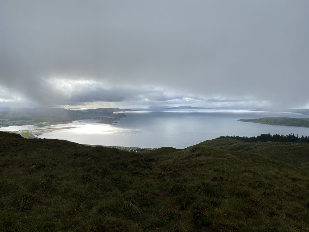
I was the only one who took the short out and back to a view point called, I think, the Eagles Nest and timed it perfectly for an almost sunny view over Benderloch.
And out over Ardmucknish Bay to a distant Mull.
Onwards to the top and past what was marked on the map as Lochan Nan Ron. It was slowly filling up with moss and water borne plants.
Once out of the forest the excellent path turned into a soggy, boggy one. This is Scotland after all.
Whilst not exactly wall to wall blue, the views along the Firth of Lorn were superb. Much better than anything we had the previous day.
UF climbs to the top.
Closely followed by MM.
The view from the summit back to Loch Creran.
Patches of sunlight and a very distant south shore of Mull.
We were disproportionately pleased to see that Oban had an airport we didn’t know about and we had a grandstand view.
We were even more pleased to realise there was a scheduled flight and we had a cracking view as it took off and headed for Coll and Tiree. Small pleasures.
Looking back north towards Glencoe and Lochaber, in there somewhere.
An especially soggy part of the return path.
The showers seemed to have abated for now and we stayed dry the rest of the day and although we had a few shafts of sunlight it never truly cleared.
Considering how wet it had been in the morning we were well pleased with the result. Some spectacular crepuscular rays to see us on our way.
Over a 1000 feet of ascent, just shy of 5 miles and some pretty decent coastal views. Small hills often deliver the best results.
I don’t get to Scotland anything like as often as I want. We used to head up there many times a year for winter walks, backpacking, New Year and Easter Trips, skiing weekends etc. I managed to reach the magic 200 Munro’s mark back in 1999 (Ben Lomond if you’re interested) but in the intervening 22 years I’ve only managed to make it to 213! My mates UF and MM have become somewhat obsessed with completing them in the past couple of years and have been taking more regular trips. As part of the effort UF planned a September bagging trip and as I hadn’t done much holiday stuff I thought I’d join him. MM tagged along as did the Prof and his better half.
Hopes were high after what appears to have been a dry and sunny summer by Scottish standards but – you guessed it – as soon as we arrived the skies turned grey and for 5 days we saw mostly cloud and rain. No matter as we’d booked a very fine cottage in Glencoe and packed plenty of food and board games to keep us occupied.
The first day looked like heading north and bit east would see the best chance of drier weather. As none of us had done the twin Munro’s of Beinn Teallach and Beinn a Chaorainn north of Glen Spean (well MM wasn’t sure so that counts as a “not done”) that’s where we headed.
As you can see from the photos it wasn’t exactly wall-to-wall blue sky, but I’ve been out on much worse days (we relived a few as the day progressed). Below the cloud in the early part of the day it was ok. The first section was enlivened by an interesting river crossing – any more water and we’d have been a bit stuffed without a long trek up the valley.
A glimpse of Loch Treig below the clouds.
Pausing before the start of the main climb to Beinn Teallach.
What the intervening years have helped with is paths. Nowadays, with the popularity of hillwalking increasing, even the most remote and least known Munro’s have baggers paths up them. After a poor start we found one on Beinn Teallach and it eased what was a pretty relentless slog through soggy grass and heather.
Here’s our happy team on the summit of the smallest Munro, Beinn Teallach being exactly 3000 feet high. Its been in and out of the list over the years as survey accuracy has improved.
On the way down to the col the weather improved and we had some half decent views into the wilderness that lies to east of the Great Glen. We sat down for lunch but sadly this little spell was just a precursor to the cloud and rain returning and it was pretty damp and dismal for the rest of the day.
A few hardy souls carried on to the second Munro of the day, Beinn a Charoainn. As you can see from the photo below of the summit party, the weather was actually pretty grim by now. Strong winds, driving drizzle and zero views.
You’ll have to imagine the spectacular drop of the east face and the views across to Creag Meagaidh
We hurried down out of the cloud and over the final top of Meall Clachaig. This was ironic as after returning to the the cottage and cleaning ourselves up we headed to the famous Clachaig Inn in Glencoe for a meal! I can report it’s substantially improved since my early Scottish hill days with a great choice of food and beers and a pleasant bar area. To be honest it was a shit-hole back in the 80’s and 90’s but we spent many happy hours in there after climbing the Glencoe mountains, especially the Aonach Eagach which sits directly above. When you’ve completed one of the best rock ridges on the mainland then I think a pint or 3, or 4 or more is entitled. Age has caught up and a couple of pints had us ready for bed. Not a bad day out all things considered and a decent workout at 13 miles and 4,000 feet of ascent.
Day after we took the Prof back up north and a very uncertain forecast had us reaching for a two wheeled day out. The Marches of north Herefordshire and Shropshire were the target and a route that I hoped would avoid the steep hills around those parts.
We set off from Wigmore with a route that I’d scouted that stuck to smaller lanes as far as possible. We were late setting out and stopped early on at Bucknell for lunch on a picnic bench by a dried up stream in the middle of the village.
Had we pressed on a couple of miles we could have lunched at this much nicer spot next to Hopton Castle.
There were benches and picnic tables and grand views out to the rest of the wooded hills that characterise the Marches.
This castle was of particular interest. My parents have lived for many years on an estate with roads named after castles. Their’s is Hopton Drive and I’ve always been keen to see its inspiration.
Whilst there isn’t much to see (and no battlements or spiral staircases) they have done a superb job of restoring what there is and as the sun came out it looked rather fine. It was built not as a defensive measure but as sign of power and wealth by some Welsh Power-monger. Interestingly all the others on my parents estate are much larger castles all within 20 miles of each other on the north Wales coast (Flint, Rhuddlan, Ewloe). Not suite sure what the connection is with this castle some 100 miles away.
We pushed on through quiet lanes to reach Leintwardine on the farthest flung north corner of Herefordshire (our route had taken us in and out of Herefordshire and Shropshire as we went round).
Its the river Teme here, a tributary of the Severn, rather than the Wye, ending at Worcester.
We were scouting this as a possible swimming spot and the water did look deep and inviting. We did have our swimming stuff with us but it was a bit chilly (and busy as you’ll see)
One of the best things about cycling in this part of the world is there are plenty of nice villages and even better country pubs to stop off at. This one (The Lion) was hosting some kind of vintage tractor rally, hence the area surrounding the river bank was somewhat busy to be stripping off!
Such opportunities for a mid-ride/walk pint can’t be wasted with the cold winter approaching and we found a grand spot for a cold pint of cider (or lime and soda for TBF)
Happiness is a riverside pint on a cycle ride.
From there we finished out by following the Teme into the countryside before returning to Wigmore.
Another 25 miles in the bag and a quiet and interesting route that will definitely be repeated, next time with a meal at the pub (the food looked great)
I spend alot of my time surfing the web looking for ideas on places to go, walking routes, travel ideas and tips to plan the perfect holiday or day out. (I'm a project manager I like to plan). I thought it was time to share my own experiences and contribute to the vast amounts in information that's already out there.
I'll also add in some gear and tech reviews and when something irks me I may even use this forum to have a rant - I do that pretty well I'm told.There are a few pages at the top that give a bit of background to what I like to get up to and what you can expect to see in my posts. I'm not exactly a creative writer but I hope some people will find my stuff useful or inpsiring or at least enjoy some of my photos.