Last weekend was appalling weather-wise. Saturday was grey, wet and dreary. Sunday a day of heavy showers no more than a few minutes apart. I tried to head out into one of the gaps for a stroll on Garway Hill. Sadly I got my timing wrong. As I set off this was rapidly heading my way.
This was the weather window I was trying to catch, vanishing into the distance.
I managed about 15 minutes of these views and staying dry before the first drops of rain fell.
Then the heavens opened and I got a real soaking.
In these uncertain and restricted times I’ve learnt to enjoy any time outdoors regardless of conditions. You never know when events will take it away again.
So I enjoyed my walk and tried to look at the rain as TBF always says as “refreshing”.
It had pretty much stopped by the time I got back to the car. Even though I was soaked through and had to put something on the car seats to stop my soaked trousers sharing their water, I was glad I made the effort. Looks like I’ll need that same positive outlook for the next few days as well. Looking pretty wet!
Last weekend and I was on my own and a chance for a walk. I was after somewhere a bit different, perhaps a new area. Definitely in Wales as another lockdown there seemed imminent.
There is clutch of wild land north of the Brecon Beacons that I’ve seen on maps and from a distance that had some summits on my hill lists. A bit of research and I had a vague plan. I parked up at the small lake of Llynheilyn, no-one around and headed into the hills.
The first couple of miles was on a broad grassy path traversing high above the rolling hills and farmland of this lonely corner of Wales. It was grey and overcast day, not great for photos, a sort of washed out feel. It was calm and dry and I had the hills to myself so no complaints. It was incredibly quiet and peaceful and a good day for just stretching out and covering some miles in my own head-space.
Ahead was my main target, Gwaunceste Hill. The highest point in this corner and a new Marilyn in my quest.
These are The Four Stones, part of some old burial ground. There were actually five stones but who’s counting – me obviously.
Onwards to try and find the best way to the top. There wasn’t a path marked to the summit itself and the deep heather and gorse didn’t look very inviting for a direct off-piste attempt.
Views to the distant Brecon Beacons.
A sort of spiralling route got me to the top. Sitting in vast expanse of pathless heather moorland its one of the loneliest spots I’ve been to for a while. The grey skies and quiet windless day made it feel all the more isolated.
I paused to check the map to see where I might head next. I took off south hoping to find some paths to take me east towards the next large sprawling mass of moorland, Llanfihangel Hill.
I threaded together a few unmarked tracks till I was overlooking the Cwmceste Vally. It was all rather pleasant in a very undemanding way.
I followed the rights of way down to the bottom and headed up the valley to the Access Land, where I hoped I could pick up some paths to the next tops.
More unmapped paths took me easily up to the top and the maze of tracks that wander around on Llanfihangel Hill.
The summit was almost indistinguishable from the rest of the landscape. Another lonely and isolated spot that must see very few visitors.
Looking into the Radnorshire and West Herefordshire hills.
I wandered about in no particular hurry or direction looking for a spot for lunch. The summit (if you can call it that) of Caety Traylow was marginally more pronounced and just below I found a fine spot overlooking a broad, nameless valley and settled down for break. Just like last weekend all was peaceful solitude until the inevitable buzzing of trail bikes. They broke that wonderful silence for pretty much the whole time I was sat there trying to enjoy this wild and lonely spot.
I headed down, thankful that peace had returned. My only obstacle an electric fence strung out across a right of way with no way to cross it. I had lie on my back and roll myself under it. Ironic that the fixing points were just below the path signs!
I picked up a fine path through the long valley and then up and over a small hill on my way back to the car.
Llynheilyn came into view and this was the best portion of the walk. The rolling green hills of Radnorshire looked very fine even under a grey sky.
The lake itself was wonderfully quiet, rippled only by the wakes of various waterfowl.
A very nice way to finish an exploratory walk. I enjoyed the small scale challenge of threading together a route in an area that doesn’t appear in guidebooks or online. It’s a walk I’d be more than happy to repeat.
I hadn’t seen a single person walking all day. As I arrived at the car I chatted to a nice couple of ladies who been out horse riding through pretty much the same route as I’d just done. I was surprised I hadn’t seen them. In these times with images of crowded summits and car parks it does prove that with a little research you can still find untouched areas with their own quintessential charm.
And I’ve now reached that rare position of being up to date with the blog. Not sure what the next few weeks will hold as lockdowns again become common. Possibly more retro posts from the past if I have time and inclination.
Another weekend and much better weather. Cool and breezy with showers normally delivers some great views, cloud effects and sunny spells so it was off to the Brecon Beacons (before talk of more lockdowns might prevent us). Keen to stay away from the crowds on the central part of the range we headed for the peaks of Fforest Fawr just to the east. Named after an old hunting forest, the trees have long since gone.
The route starts with a long traverse across the base of the cliffs of Craig Cerrig Gleisiad.
A fine start to the day with grand views towards Brecon.
And over to the central peaks of the Beacons, here looking moody and magnificent.
Turning back south the views over the pastures and hills of mid-Wales open up
And back towards Herefordshire, Shropshire and the Black Mountains.
The threat of showers seemed to be diminishing and it was turning into a rather gorgeous sunny day.
On to the summit of Fan Frynach.
We stopped for an early lunch (for TBF mainly, I’d had a big breakfast)
Cracking views and hardly anyone about. Perfect peace and quiet. Until……
The new plague of the mountains – trail bikes – arrived. Around ten of the buggers noisily buzzing their way around the hills, churning up paths, and stinking the place out with fumes. We took a narrower path to keep a bit of distance. They were halted by a locked gate. We were close enough to hear their discussion, seriously considering taking the gate off its hinges so they could get through! That’s the senseless and selfish attitude they have. Fortunately they seemed to think better of it and returned the way they had come. These things are becoming a real problem in South Wales such that it’s rare to take a walk down here without them these days. Not sure what can be done if anything. I head to the hills to escape from the noise and fumes of everyday life. It saddens and angers me in equal measure.
Let’s get back to enjoying the walk. Onwards and across a fairly soggy stretch towards the highest summit in Fforest Fawr, Fan Fawr.
It’s a steep but short off piste bash up to the top but the views were superb with abundant blue sky and clear air that comes with showery weather.
Looking across to the Black Mountain.
And Corn Du.
We found a nice sheltered spot for second lunch and a brew, tucked under the edge near the summit. Another stop somewhat spoiled as the trail bikes returned.
A very steep drop down to Storey Arms. Steep enough for me to slip over and realise the easiest way down was a bum-slide!
To return to the car involves a very quiet and pleasant stroll along the Taff trail and then a steep climb back up to the road. As we crossed the river we were treated to a gorgeous clear patch of blue sky and sunshine.
It made the final uphill push a little more bearable
The autumn colours really starting to put on a show.
And I’m always a fan of an autumn tree silhouette shot.
After plentiful sunshine at the end of September the move into October told us to get real and get used to rain. The weekend after our wonderful day out in Roaches was dreadful. It rained pretty much non-stop from Friday morning through to Sunday Morning and it looked like another walk would have to wait. As afternoon was ending the skies started to clear and it looked worth heading out.
Garway Hill was the obvious choice with its high car park.
By the time I set off the weather had improved significantly with even some blue sky and watery sunshine. This is Graig Syfyrddin, the hill with not enough vowels.
I followed my usual short route across the eastern flank to the ridge and up top the top with its strange wall-enclosed structure.
To the north into Shropshire the weather was actually looking pretty decent. If I’d realised, we could have probably got a decent day walk in, up that way.
Looking out over Gloucestershire, May Hill with its small woodland patch prominent in the middle of the photo.
Ysgyryd Fawr and the Sugar Loaf.
The rolling fields and orchards of Herefordshire
Moody skies.
And the more cheery blue variety.
I was enjoying being out having been cooped up in the house for a few days so I went back to the top again on my way to the car.
A view to the Malverns on the skyline.
And the local ponies sending me on my way.
I was expecting gloomy skies and nothing more than some fresh air. Turned out to be a pretty decent walk. Glad I made the effort.
The last of these “Indian Summer” posts. This one goes back a couple of weekends after which the weather has been more normal i.e. largely grey and wet.
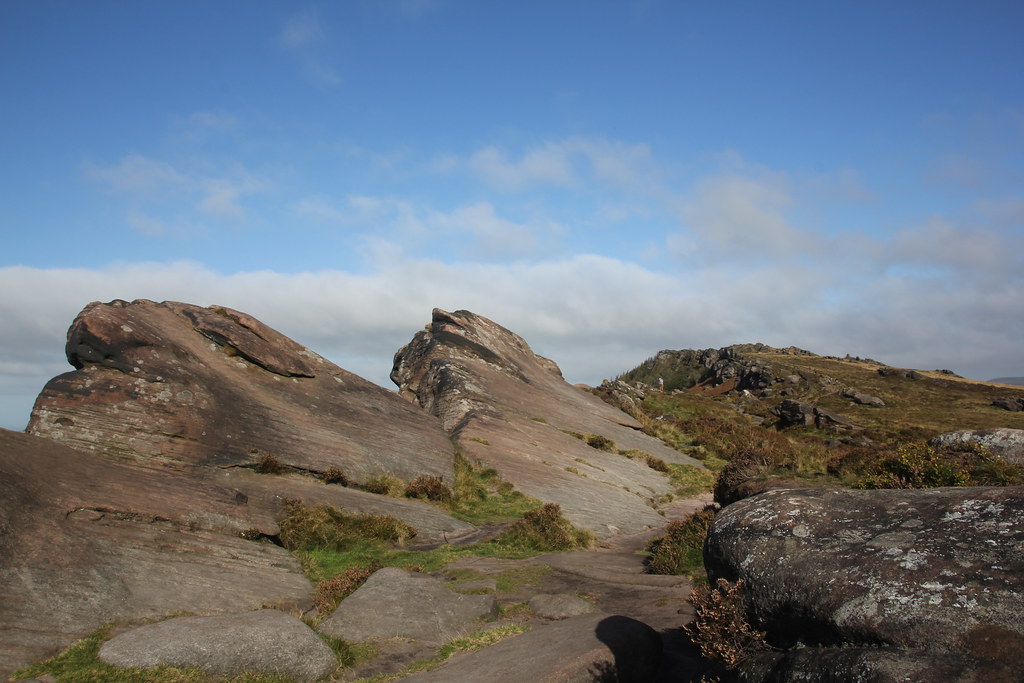
We again met up with friends for a walk and settled on The Roaches as a place we all know well, with great walks and easy to get to. Another glorious day, a little chillier than previous walks but once we were out of the breeze, pleasantly warm. We’d planned an early start (just after 9 – its over two hours from home) and just as well – car parking was full shortly after.
Gorgeous clear morning with expansive views.
We picked our way through the lower and upper tier of crags, some scrambling required in places by sticking close to the edges.
The sandstone rock looking very fetching the clear autumn sun.
Happy hikers enjoying a fine day out.
Up onto the edge from where the walk is easier and a joy to follow the edges. The Dark Peak edges are a fine place to spend an autumn day.
This is the Doxey Pool near the summit.
Having been up since 6:30 and no breakfast it was time for an early lunch and brew. A chilly morning but pleasantly warm, sheltered from the breeze.
Onwards along the edge…
And to the summit rocks.
Even though it was less than an hour after first lunch we decided it was time for second lunch! We found a spot completely sheltered and it was wonderfully warm and sunny, almost summer-like. We stopped for a good while enjoying good company, something lacking in this terrible year.
We cut back down into the Dane Valley, opting to miss out the muddy dark hole that is Luds Church in favour of the sunshine.
We managed to construct a rather fine route (with the odd soggy bit) heading across the fields and moorlands towards an un-named edge near the Black Brook Nature Reserve. These are Gib Torr Rocks.
This fine specimen of rock is also un-named but it made for a great afternoon tea-stop.
The views across the western White Peak towards Shutlingsloe were superb.
This rather quiet and unprepossessing section was a delight. A braod grassy path studded with rocky outcrops.
We were heading for Ramshaw Rocks by way of return to the cars. We walked this way a couple of years ago on a truly wet and miserable day and saw almost nothing of them and I was keen to see them properly this time around.
They are superb. The edge is less pronounced but the rock has been eroded into wonderful shapes that were perfectly lit by the afternoon sun.
Looking across to the main Roaches edge.
And down over Ramshaw Rocks.
When I lived up this way about 20 years ago it was before the right to roam acts and they were on private land. I always wanted to see them while I was walking the Roaches and seeing them up close was a delayed pleasure.
I was in my element scrambling to the top of the various outcrops. I was getting looks from some members of the party who were late for a sunday roast so we had to press on.
We arrived back at the col between The Roaches and Hen Cloud. We were all parked up in different spots so we said our goodbyes (who knows now for how long) and headed home.
Hen Cloud.
The Roaches
Across to a distant Ramshaw Rocks.
And last lingering looks to Hen Cloud and The Roaches from the road to the car.
It was a long day with a 2.5 hour return drive and over 11 miles of walking. Worth every mile and hour on such a superb day. I hope we can find a way to continue to meet up like this but with many of my friends living in the north and now effectively under a new lockdown then who knows if we will be able to. For now I can take some solace from the fact that where I live seems currently to be coping better for whatever reason and I can still head for my own local hills. I like a solo walk but there is nothing better than sharing a great day with like minded friends of long-standing.
The gorgeous late summer, early autumn weather continued. A minor glitch with my contract at work gave me an excuse for a day off to make the best of what looked like the last day of warm weather. Up early and away before 7am on my way to Snowdonia. First up, breakfast in a nice picnic area overlooking Llyn Clwyedog.
My target for the day, the Rhinogs. The weather was clear and under a blue sky I thought its collection of small tarns would make for a great day and possibly a final wild swim of the year. Parking up on the east side ay Graigddu Isaf, Rhinog Fawr dominated the view.
An easy start through the forests, the path seems to have been improved significantly since my last visit when it was very wet and soggy.
Past the pleasant waterfall of Pistyll Gwyn.
And out into the wilds of the Rhinogs.
For reasons that I’m not sure of, this part of the range has never been farmed or grazed. The result is a complex terrain of rock and boulders, studded with small blue, clear tarns and smothered in deep heather.
It’s stunningly beautiful but that terrain makes it tough going. Paths are plentiful but thin, difficult to follow and extremely rough. As I approached the pass at Bwlch Tyddiad, I ventured off into the wilder heart of these strange and impressive mountains.
Suddenly, the first of these tarns comes into view, Llyn Du. Its a magical spot. The water crystal clear and surrounded by rock.
It would be a superb place to camp if only you could find a flat, dry spot. Trouble is, that’s very hard to find in the Rhinogs.
There are a couple of options from here to the summit of Rhinog Fawr, both steep and both very rough. I traversed around the shore including a delicate scramble across the slabs in the photo below. It was still early and I wasn’t ready for a swim just yet.
There are thin sheep tracks all over the place and by linking these together you can make slow steady progress through the complex terrain. Needless to say I would not want to try navigating my way around here in the mist. Looking down on Llyn Du.
North towards the Glaslyn estuary and Snowdonia.
North over the even wilder section of the range, a few sheep for company.
The final section crosses some very steep scree and for a few minutes its quite loose and hard work. Eventually after what seems like a really tough climb you emerge on the spacious summit of Rhinog Fawr.
On a weekday it was completely deserted and even though I stopped for a long lunch and a brew I had the whole place to myself.
Looking across to my next target, Rhinog Fach with Llyn Hywel just glinting in the sun.
The summits are the only easy places to camp and it’s a long held ambition of mine to do just that. Hauling a heavy pack including water up here would be a tough ask though.
Looking east to the Berwyns and Arans.
I’ve stressed how tough the Rhinogs are and this is where it really kicks in. The route between Rhinog Fawr and Rhinog Fach is one of the toughest sections of walking outside of Scotland. A thousand feet down and then and another thousand back up in less than 2 miles as the crow flies. The path that descends Rhinog Fawr is steep, rocky and very hard to follow, disappearing into huge blocks of scree several times. Its a case of watching your feet all the way and picking your way down.
It’s something of a relief to reach the bottom at Bwlch Drws Ardudwy. That is, until you realise the ascent back up is even steeper. Its pretty much a direct line straight up the left hand depression in the photo below.
It was a long hot climb. It’s mentally tiring as much as anything as you have to constantly watch your feet on the rocky path and keep an eye on where the path goes. Having the OS Maps App is a great help here in pinpointing your exact location (I do of course carry a paper map and compass, never rely on technology!).
Of course the rewards are the sensational views and what the Rhinogs lack in height (only around 700m) they more than make up for in spectacular landscapes and coastal views. Hence the broad selfie smile as I enjoyed yet another summit all to myself.
Although the smaller of the two Rhinogs, Fach is even more precipitous and as the jewel in its crown it cradles the magnificent tarn of Llyn Hywel. I was anxious to see it up close and maybe take a swim.
Its even more spectacular close up, almost the perfect mountain tarn. Enclosed by the dramatic cliffs of Y Llethr and Rhinog Fach with huge slabs of rock dropping directly into its depths.
Down by the lakeshore I stopped to chat to a very friendly group of ladies sunbathing and enjoying the mountains. They were the first and only people I met all day. They had been swimming and I was now keen to take a plunge myself.
I’d spotted some rocks over on the far side that still seemed to be catching the sun and I hoped out of the breeze. A short scramble across the rocks and it was the perfect spot. I changed and climbed in the water. Man, was it cold. I dared not swim too far away from shore as the cold was making my muscles ache. It was absolutely stunning though and so glad I took a dip. I even managed a couple of jumps from the rocks (the DBs would love this spot, if not the effort to get here)
I’d earned another feed and another hot cuppa to warm myself up whilst lying back on the warm rock and feeling pretty good.
I spent quite a while here and really fell in love with this wild and amazing lake.
It would not look out of place in certain parts of the Alps or Pyrenees.
Sadly, I had to move on as I still had a fair walk back to the car.
A chance to enjoy more dramatic vistas.
And another selfie to mark the moment. I have a love of Llyn y Fan Fawr in the Black Mountain and always note it as my favourite mountain tarn. Llyn Hywel has knocked it off that illustrious perch.
A final view of Rhinog Fach.
My return route followed another fine if thin path around the western flanks of Rhinog Fach and past another small tarn, Llyn Cwmhosan.
It was partially dried up and nothing like as impressive as the other two tarns on my round.
The route took me back through Bwlch Drws Ardudwy from a different direction.
Effectively making a figure of eight route. At the col I took a better photo of my route of ascent up Rhinog Fach, the dark line below. It still doesn’t convey just how steep it was.
All that remained was to walk out through the pass and then back along the forest tracks to the car.
A final lingering shot of the sun going down behind these two, tough but rewarding mountains.
Only 8 miles but it packs in over 3000 feet of ascent and feels like a really tough day.
Last year around this time, we had a mass gathering of all our friends up in the Lake District. A fine weekend in a nice guest house with a meal in a local pub. This year….. (I think you’ve guessed the punchline).
As an alternative we planned a meet up for a day walk. Originally we had the Peak district in mind but then this rather arbitrary rule of six came into force, we were unsure if (and if yes why) that was a problem outdoors, and we thought there would be more than six of us. A quick check of the ever increasingly complex regional rules indicated that gatherings of up to 30 people was still allowed, outdoors, in Wales.
Change of plan and we agreed on a meet up for a walk around the Limestone edges near Llangollen. In the end there were only six of us anyway but no matter, its a fine area for a walk. We met up for a car park picnic area fry up. Skies were cloudy at first but the forecast was for clear blue sunny day and within a few minutes of setting off the clouds began to break and all was sunny for the rest of the day.
The first hour of the walk took us along valley paths, and past Valle Crucis Abbey and its very fine looking campsite. The hills above the Horseshoe Pass began to appear.
And then you round a corner and the dramatic limestone edges of Eglwyseg Mountain suddenly come into view.
They are a spectacular sight and as good as anything in the better known limestone areas of Yorkshire and Derbyshire.
Even better is Offa’s Dyke path that traverses under the cliffs as a truly superb balcony trail. To one side the green vales and heather clad mountains of Llantysilio to the west.
Above the dramatic limestone edges.
We found a rather splendid grassy spot in the sun for first lunch and brew.
The cliffs are not especially high but I think the deep valley’s beneath give them an increased sense of scale and height. Especially so under a clear blue sky.
Appetites sated we continued on Offa’s Dyke.
Every step a joy and despite its impressive grandeur, almost deserted even on a sunny Saturday. Its up there with the finest paths I know and drop it into the Lake District or Yorkshire Dales and it would be queue of walkers along its length
The path climbs steadily and imperceptibly up to the edge near Craig Arthur and before reaching the wonderfully named Worlds End. Here you turn back and take a thin path, not marked on maps that traces the line of the crags you’ve just walked under.
Cue dizzying views over the edges. It’s a truly spectacular walk. I love the contrast between the exposed white limestone and the dark heather clad moorlands nearby.
So enjoyable that we decided another stop was in order.
Its quite a long edge but the path has improved over the years and the walking is flat and trouble-free. Miles are easily covered.
As the path continues the edge drops away and Castell Dinas Bran comes into view.
Time to work out how to get down through the bands of crags.
A short, sharp and steep descent brings you into the disused quarries of Trevor Rocks. Even though these crags are artificial the levels have grassed over and its an equally fine walk through them.
The crags were busy with climbers enjoying the warm sunshine.
It really is walk of almost un-ending quality.
A drop to the road with some views back across the line of cliffs and time for the short steep climb to Castell Dinas Bran.
A view along the valley of the River Dee. The Pont Cysyllte Aquaduct visible in the distance.
What the castle lacks in ruins to explore (they are very scant), it more then makes up for as a spectacular view point.
After another stop for snacks and a cuppa, time was pressing on and the light already starting to fade.
Time to head down and think about returning to base.
An enjoyable final stroll along the Llangollen canal by the river Dee. We walked past the Chain Bridge Hotel and on a whim decided it was just about warm enough to sit outside for a pub meal and a pint. Even though it was pitch dark and chilly by the time we finished we all agreed that not only had it been a cracking good walk but that finishing off with a sociable meal with friends was perfect and something we’d all missed over the last few months.
A long walk over 12 miles but one of the very best not only this year but of many years.
Back to the UK and two weeks of enforced quarantine. I’ll steer away from anything other than an oblique reference to what a pointless exercise it was. We dutifully obeyed and used the time to get a bunch of domestic chores completed in the hope that we’d be able to fully enjoy any subsequent good weather without fretting about said chores. Things worked out well as September, as it often does, delivered a great spell of sunny weather (hence we have a phrase for it) so the first in a series of sunny walk posts.
First up TJS needed to head back to Lancaster Uni so rather than just drive there and back we decided to squeeze in a walk. Its only a 10 minute drive to the Rigg Lane car park that gives access to the fells of the Forest of Bowland in in particular Clougha Pike. I’ve heard many good things about this small hill so I was keen to see it, especially having never walked in the Forest of Bowland before.
It was actually quite hot and the air very still when we set off so it was a sweaty climb through the trees and bracken till we reached the open fell side.
The Forest of Bowland used to be off limits to walkers when I lived up north other than a couple of permitted routes. The Right to Roam measures brought in maybe 20 years back have opened it up. Just as well as this stretch its really rather lovely.
We emerged at Windy Clough and as we started our climb towards Clougha Scar there was just enough breath of wind to keep us cool.
There is a fine path that follows the edge all the way the summit.
Looking out across Lancaster and Morecambe Bay.
TJS trying to look and stay cool in the heat. It was more August than mid-September.
It was very hazy so the distant views were not great. This one if you strain your eyes is off all the Yorkshire Three Peaks.
And over to Grit Fell and the rest of the vast expanse of the Forest of Bowland.
We had a nice long stop on the top, mainly so I could have a cuppa, and as is our want, talked all things football.
We decided to extend the walk a little to Grit Fell. I imagine this would be a very wet and soggy trudge in winter but today it was bone dry.
The summit of Grit Fell looking towards Ward’s Stone, the highest point. I had an idea to walk out and bag the top (its a Marilyn!) but it looked a long way and the actual top is another km out behind what you can see. Another day.
We headed back along the tracks on the north side, taking in the Andy Goldsworthy sculptures. This one doesn’t seem to have a name (other than “Clougha Pike”) and I can’t find out much about it or what it’s supposed to represent. They are impressive and the first of his I’ve seen. The painstaking effort it must take to create them is obvious.
It was starting to cloud over as we headed down and I was surprised in these conditions that we weren’t attacked by midges. All their resources deployed elsewhere I guess.
There were some other odd looking cairn structures as we headed down. Again, no idea what they are but they did make fine photo subjects.
At the base of the fells there is quite an impressive ravine. This photo is taken from a bridge that I believe carries the water pipe from Thirlemere to Manchester.
Another odd looking stone construction next to the path.
The last stretch back to the car through open woodland was rather lovely although the clouds were beginning to look rather threatening. Indeed after a shopping trip and a KFC dinner as we walked back to TJS house it was spitting with rain. On the subject of his new house, students clearly have things much better these days. I lived in some pretty grim places when I was at Uni, but his new pad has a huge plush bathroom with walk in shower, flat screen TVs in every room and a properly equipped and clean kitchen. I was pleased and outraged in equal measure.
As we walked back we were treated to a quiet an amazing sunset. It was hard to capture from the city streets to this is the best I could manage. Later I saw a whole raft of truly amazing photos from my FB feeds from various and much better spots in the NW and Lake district.
An enjoyable day but a sad one. Speaking selfishly its been great having TJS at home with us during the Covid mess and the house feels very empty without him around especially as most days I’m working at home in the house alone. With the current restrictions in place, I have no idea when I’ll see him again.
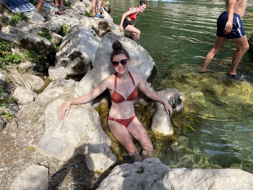
While driving to and from the shops I’d noticed some impressive looking deep pools and people in canyoning gear just below the Pas de Soucy where a massive rockslide has blocked the river. I decided it needed investigation and gathered a hardy band of volunteers to come with me.
It was an inspired move. Below the boulders the river runs through a small mini gorge with extremely deep water, studded with huge rocks and small cliffs. Perfect for jumping and long swims.
It does lack any kind of pebble beach so there is very limited space to sit in the sun. TJF found this amazing rock, perfectly sculpted into a throne for sitting in the water. Made a wonderful photo.
We went down a couple of times after our two walks. All agreed that it was the best swimming spot we’d been to.
DB Junior doing what he always, and I mean always, does. Promising he won’t jump right next to while you swim by then doing exactly that!
The water looks calm but there was actually a fairly strong flow that gave good exercise trying to swim upstream against the current. The stretch of deep water is huge so perfect for anyone that enjoys a longer swim while others play on the rocks.
There are a couple of springs feeding into the river here so the water is bit chillier but still much warmer than the Ceou on our Dordogne campsite.
Father and son.
One of the rocks the DBs found for jumping.
Another little slo-mo video of their antics.
We explored all the way up to the boulder jam. No photos as it was a swim only and I didn’t fancy losing my phone in the deep water. We had some great fun trying to push past the ever faster flowing water in the rapids. We reached the point where the Tarn flows through a gap in the boulders only a couple of feet wide. Safe from below but easy to see why they implore you not swim above it. You’d be in big trouble if you got swept into that part of the ravine.
Lots of jump potential from the cliffs on the far side.
These looked slightly too high to jump from!
The snorkelling was great as well. Deep, clear calm water and loads of large fish.
There is a campsite right next to this stretch and all agreed that when we return as we surely will that we need to give it a go. It really is an amazing spot and perfect for all the various river play options.
This was our last afternoon of the trip. We returned for a final meal of burgers, packed up in the rain the next day for a very wet drive home.
Absolutely superb trip. Magnificent scenery, kayak trips, river fun. All spent in the company of great friends. Just the tonic in these extraordinary times and worth every minute of enforced quarantine when we got home.
There is a path that traces the route of the gorge for its whole length through the Cevennes. It would be a superb walk as it winds its way through the various dramatic ravines and under cliffs with plentiful places to scramble down and take a dip. Unfortunately it runs along the opposite bank of the river to the campsite and we were unsure how far up the other side it was without any obvious way to reach it.
So one afternoon with nothing better to do I waded across the river and started searching the undergrowth for a way up the other side. I wasn’t hopeful and trying force a route through the dense trees would be impossible. Within a matter of a few strides I came across a thin path and then some cairns. Following it upwards there was a distinct path (easy to follow if a little steep) and in 5 minutes brought me to the main path – result!
A hardy band of kids and adults decided to take on a walk a couple of days later. Here they are emerging from forest.
Faced with a choice to walk upstream or downstream we chose the latter.
Another gorgeous day of endless blue skies and sunshine.
The gorge is liberally sprinkled with woodland and forest. Whilst it limits the views somewhat it does provide welcome shade.
If you look closely in the photos below you can see the bungee jump platform. They were open for business today and we could hear the screams and shouts from those taking the plunge.
The Cirque des Baumes we walked down previously.
Sunshine and shade.
A glimpse of the river far below.
We walked as far as the point where the gorge hangs a sharp left and heads south towards the village of Les Vignes. The huge pointed rock in the photo below is part of landslip that I guess it the root cause of the Pas de Soucy where huge boulders block the river and it tumbles through underneath (no kayaking through). More on that part of the river in the next post.
TBF enjoying the walk immensely.
We turned around to retrace our steps. More of the same fantastic views.
Back in time for a well earned lunch and more river based antics in the afternoon. Not a bad combination to spend the day.
Later in the week the weather turned a bit. We had one day of heavy rain and the next day was cool and cloudy but dry. Time for another walk and another scramble up to the path.
This time we headed upstream heading for Les Detroits. A much harder walk as the path dropped all the way back to the river before heading all the way back up and above the narrow gorge of Les Detroits.
The weather was starting to improve and we caught some good views of the crags above.
Although the view down into the narrows of Les Detroits and the river were hard to find.
As we headed back the first semblances of blue sky began to appear, heralding a much better afternoon and some more river based fun and games.
As we crossed the river back to the campsite, Mark spotted a snake lying dead in the water. It had stunning colours but was hard to photograph. This was my best effort. Such a shame it was dead. Or so we thought. While we watched, it suddenly slithered off quickly and climbed into the bushes on the river bank. I was well chuffed. I knew snakes were good swimmers but I didn’t know they could stay underwater for any period of time, clearly hunting for food.
I spend alot of my time surfing the web looking for ideas on places to go, walking routes, travel ideas and tips to plan the perfect holiday or day out. (I'm a project manager I like to plan). I thought it was time to share my own experiences and contribute to the vast amounts in information that's already out there.
I'll also add in some gear and tech reviews and when something irks me I may even use this forum to have a rant - I do that pretty well I'm told.There are a few pages at the top that give a bit of background to what I like to get up to and what you can expect to see in my posts. I'm not exactly a creative writer but I hope some people will find my stuff useful or inpsiring or at least enjoy some of my photos.