Couple of weekends back we had a forecast that gave a possibility of a cloud inversion so we headed out early to see if we could get up high and above the cloud.
It wasn’t a nailed on forecast and it certainly didn’t look like that sort of day when we set off from home, just a normal grey November day.
When we parked up there was abundant blue sky and sunshine over the Wye Valley.
But all the summits were cloaked in what looked like dense cloud cover.
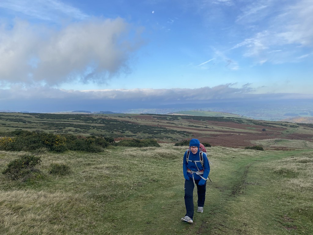
There was also a very strong wind, not normally something you get with inversions and it was bitingly cold. TBF doing a great job of looking cold!
As we headed up the Offas Dyke path we gradually became enveloped in cloud. It was damp and not exactly great walking but we were enjoying just being out and about.
We did get one very brief window in the cloud from the summit of Hay Bluff and it was worth the trip out just for that.
However our hopes for more of the same were not to be satisfied as we were in thick, cold cloud all the way down to the Gospel Pass.
We had thought about walking up to Lord Hereford’s Knob but it was also shrouded in cloud and we headed back to the car along the road.
It was still sunny, albeit cold and windy back at the car.
An atmospheric walk if not a sunny and above the cloud one.
Bonus Content! A few pictures from a walk through Lugg Meadows near Hereford. This is regular walk for me while TJF has her Driving lesson. I took the pictures mainly to show how high the river was compared to my walks in the summer. I thought I had some photos that would give a good frame of reference for the change in the water level, but sadly I don’t see to have. You’ll just have to take my word for it that it was 5-6 feet higher, quite a lot for a small local river like the Lugg.
Mistletoe in the trees. It grows everywhere in Herefordshire.
Its one of my favourite local walks although I had to cut it short on this occasion as the river had flooded part of the path and meadow and I only had trainers on.
It all seems a far cry from just a few months back when I walked along here and thought about a swim to cool off!
We don’t seem to have been out anywhere terribly exciting (or sun drenched) in most of October judging by my photographs.
These first couple of photos are taken from a walk to Arnside Knott the day after we’d visited the Lancaster Music Festival. A fine event with loads of bands, many local, many from further afield and all free.
Arnside Knott always delivers a fine walk and even though the weather was on the turn we managed a summit brew and sandwich stop and a visit to the pub on the way back.
The classic view out to the Lakes over the Kent estuary.
Last weekend in October, the Prof came home for a visit. We filled the first day with breakfast at our local garden centre, a visit to see my mom and dad and then a meal at our favourite local burger bar. We were keen for a walk on the Sunday and the forecast was sunshine and heavy showers. We figured our best chance of avoiding the rain was to head away from the mountains so picked the Malverns for a bit of a walk.
It was cool and very windy but there did seem to be sunny intervals about.
We walked the middle section which what it lacks in height it more than makes up for in up/down with several small summits to traverse.
Looking back to the Hill Fort of Herefordshire Beacon.
For a while, the sun came out and it was really rather splendid.
The highest point, the Worcestershire Beacon, started to loom large in the distance.
Walking over the succession of “hills”, Black, Pinnacle, Jubilee and Perseverance.
As yet no sign of any threatened showers.
It looks very autumnal.
Although it wasn’t really shorts weather.
We decided we had time to climb to the top of the Worcestershire Beacon and set up for the long plod to the top.
Looking back we saw the first signs that all was not well with the weather.
Looking down over one the Malvern towns. There are several “Malverns”, Great, Link, Little etc. This is Great Malvern, the main town.
Looking out over the northern outliers, weather looking ok.
However, looking back south, where the car was it looked rather less than ok. The first drops of rain arrived as we reached the top.
We didn’t linger but halfway down it started to rain with a real vengeance. For about an hour it was a nasty a spell of weather I’ve been out in for a while. Proves you don’t have to head to big mountains to get a real cold soaking and feel utterly miserable
This photo kind of sums it up.
Even though it looks brighter here it only stopped for a couple of minutes after which it got much worse and the wind even stronger. It was deeply unpleasant.
Another photo making it look benign, trust me it wasn’t. We were soaked through by the time we reached the car. Cue, trying to cover the seats with an array of items to stop them getting soaked.
Sometimes it’s just about getting out and I’m glad we did. Just wished I kept a closer eye on the rainfall radar and cut our losses much earlier!
After our day in Manchester we took a trip out to the White Peak for a walk. Its been an age since I walked the area around Longnor and Hollinsclough and the twin peaks of Chrome Hill and Parkhouse Hill so time to put that right.
We parked up in cool and windy Hollinsclough village – along with lots of other people!
Great initial views of Chrome Hill.
And Parkhouse Hill.
We took the path that skirts around Hollins Hill and above the valley that holds the infant river Dove.
Its a lovely path with wide expansive views and the sun even came out for us.
Soon you get the classic view of Chrome Hill. Diminutive in height (by UK standards) at around 470m it packs a proper punch as a classic mini-mountain.
When I used to live in Derbyshire it was initially out of bounds. They then opened a permissive path to the top and more recently it became part of Access Land. The path around the back to start of the NW ridge is superb. Grassy paths across the fields and some great views.
There is lots of access land up here and plenty of options to extend this walk on a fine spring or summers day.
The small outcrop of Tor Rock.
Approaching the start of the NW ridge.
The Prof enjoying the sunshine.
There is a really good path that twist around the narrower sections but I preferred to stick right to the crest. It gave some wonderful airy situations.
As you climb, Parkhouse Hill comes in to view.
A cave-arch through the ridge.
The summit was extremely wild and windy so despite hunger pangs we pressed on, looking for a lunch spot.
As we dropped down, thoughts turned to Parkhouse Hill and which way we should tackle it.
Considering its diminutive height its quite a dramatic outcrop, even more so than Chrome Hill.
When I lived in these parts it remained firmly out of bounds, large signs warning you it was private and there was no access. This was even after Chrome Hill was opened up.
The Rights of Way Act put paid to that so I’d never climbed it and I’d been looking forward to this. We stopped for lunch tucked behind the large pinnacle at the bottom of its west ridge.
I can say that Parkhouse Hill packs quite a punch especially on a damp day when the limestone was greasy and very slippery. There were a couple of points where I felt a little edgy and a fall would have been nasty.
I managed to pick my up but I certainly would not want to come down that way. There is a section near the top that was straightforward in ascent but would be very awkward and exposed in descent. I backed away from the ridge direct in the photo above as it was seriously narrow.
A very pleased to reach the summit selfie.
Views all around were superb. It’s a unique and striking little mountain in every respect. UF and the Prof decided against the ridge and in case anyone reads this and wants some help, there is a steep but very easy/safe grassy path up the northern flank that avoids any difficulties.
Glorious views over the Dove valley to High Wheeldon.
We decided to tackle the east ridge to descend.
Whilst it was much easier than the west ridge it was still extremely steep and needs care.
It really is a mountain not be under-estimated. Tackled along its ridge there can be few harder hills/mountains in England. Stiperstones, Helm Crag and the direct ascent of Broad Stand to reach Scafell a few I came up with.
There is a small grassy hill to the north so we took that in as well. More stunning views from the col to Chrome Hill.
The Prof and Parkhouse Hill in profile.
I like the contrasts in this image, sunshine and sheep in the foreground, dark profile of people on the ridge in the background.
We began our return by contouring under Parkhouse Hill, here looking back at our descent route.
The west ridge and the pinnacle from the southern side.
We completed the walk across the fields to Hollinsclough. I was very pleased and satisfied to have climbed this small hill having looked longingly at it for many years. The White Peak Alps!
Every year we try to arrange a weekend away in Manchester built around a match day visit to the Etihad Stadium.
We always make a full day of things and this year the supporting theme was to visit a couple of Manchester’s newly regenerated urban districts (with food and drink stop carefully included).
It was looking like a grand day weather-wise. We stayed at UF’s place near Hyde. He lives at the top of a steep hill with great views across to Manchester. As someone who lives in a rural backwater I always find it a joy to be able to travel around easily by public transport and Manchester’s combination of buses and an excellent tram system make this a integral and fun part of the day (even our first bus didn’t show up!)
First on list was Mayfield Park. The website doesn’t actually say what it was before but it has been brought back to life as an area of parkland by the river Medlock and a quite superb looking children’s play area complete with long slides that take you above and over the river.
I can imagine my kids would have absolutely loved this place when they were younger and all of three of us adults were also looking quite longingly at the slides!
Its one the best examples I’ve ever seen of just what a bit of thought (and money) can do for what I can only imagine was a derelict area before. There were loads of people enjoying the space, adults and kids alike, money very well spent. I can only hope that its respected and doesn’t end up covered in graffiti and vandalised.
Time to eat and we headed off for a huge breakfast at the impressive Koffee Pot cafe in the city (arguments still raging about who discovered it!). With some time to kill before the pubs opened we took a walk to the Cottonfield Wharf and Islington Marinas.
We’ve been walking through these areas since Manchester City moved out to Eastlands and the transformation is extraordinary.
The canal basin is another delight to walk around, an impressive green space in which to live in a corner of the city once home to a dying industry. I was as impressed with this as I was with Mayfield Park. All the walking had worked up a thirst so it was time to head to the pub for a couple pre-match beers. The Marble Arch is one of Manchester’s best, classic old style pub with its own brewery and pretty good food as well. Must take a few photos next time we visit.
And off to the day’s sporting event. The Eastlands complex that includes the Etihad Stadium is another great example of urban regeneration. The stadium was originally built for the Commonwealth Games before City took it over. Quite cleverly one of the stands was temporary so after the games it was removed so that the stadium could be dug out, removing the running track to create more seats and bring the crowd closer to the pitch. Since then the whole area has been completely transformed with sports facilities, training complexes, a second smaller stadium for the Women’s team and other youth teams. There is also a massive arena/venue under construction.
Back to football matters. Manchester City versus Southampton. Nothing beats a live game of football, especially as part of great day out.
In truth, even though City won 4-0 it wasn’t the most thrilling game I’ve ever seen but it was good to enjoy the atmosphere and a few goals.
Another walk and tram ride to Deansgate and a couple of pints in another of Manchester’s best old style pubs, The Britons Protection. A great view of the Beetham Tower from the platform. Manchester now has a pretty good selection of skyscrapers and despite the fact they are normally home to the wealthy, I do like them.
And to finish the day off, another tram ride to West Didsbury and a curry at the fab Namaste Nepal. Fine night-time view of the Deansgate Square Towers from the station. Top city day out.
We needed a trip to South Yorkshire first Saturday in October and an overnight Friday stay (reasons to be explained in a few weeks!) Rather than just head straight home we wanted to make something of the day. Having decided Chatsworth was too scandalously expensive we settled on Bolsover Castle.
Its quite a prominent sight from the M1 and a quick check of the website made it sound an interesting place and well worth a visit.
After a lunch in the cafe we went in for a wander around.
There were showers around but for the first part of our visit we were in clear abundant sunshine.
Its a really well done place with plenty of interest and it has a fascinating little place in history.
Kind of odd to see it in its location amongst the old coal mining remnants.
This is the Terrace Grange part of the original manor house from Norman times. It was besieged a few times and then fell into disrepair for the best part of 300 years.
This is what’s referred to as the “Little Castle” built by the Cavendish family who bought the estate and made it their home.
The inside is really interesting with curious rooms and you are free to explore pretty much every room and little corner.
I particularly liked the ceiling in this room.
The Cavendish family were very well connected and one the key moments in its history is a lavish event, attended by King Charles 1, all his entourage and many of the Derbyshire elite. Quite a coup for a lesser nobleman.
There is a walled garden outside which would be lovely place to relax on a warmer and less rainy day.
It gives a great perspective on the Little Castle.
Even better that you can walk all around the walls.
Not exactly battlements but very nice (until it started to rain anyway!)
During the Civil War, William Cavendish was appointed by the king to be Commander in Chief of the Northern Royalist Counties. Sadly fortunes took a bad turn, after his wife died, he lost the battle of Marston Moor and fled to exile in Paris.
The castle was the ordered by the Parliamentarians to be slighted so the Royalists couldn’t use it as a base.
However, William returned from exile shortly after and granted the estate to his sons who repaired the place. It then passed through various families for a few hundred years and again began to fall into disrepair including pollution damage from nearby factories and coal mines in the early 20th Century.
Eventually it was taken over by the Ministry of Works to effect repairs and has been open to the public since 1945. English Heritage are now custodians and attempting to restore as much as they can to former glory.
A fascinating place and well worth a few hours for a stopover when you’re in the area, especially as its only 10 minutes from the M1.
Our last day dawned much brighter, much colder and much windier. Everyone else had either gone home or was heading home but with a decent forecast of sunshine and some isolated showers I reckoned we could fit in another mountain day. As its an iconic mountain only just off route that The Prof had never done, The Cobbler fitted the bill.
When I last did the Cobbler (admittedly over 30 years ago) the path up was a grindingly steep and muddy climb through the Ardgarten Forest, pretty much straight up the hillside.
Times have changed and its popularity has made possible a well engineered path that zig zags at an easy angle – and no mud – through the trees. There were breaks offering our first glimpses of Ben Lomond.
As you emerge from the forest you gain your first view of the iconic anvil shape of the Cobbler. It must be one of the most recognisable mountain profiles in the UK.
Ben Lomond looking equally iconic from this direction.
The nearby munro of Beinn Narnain.
The main routes to the summit are either steeply up to the col between the central and north peaks or the slightly less steep north flank. However I’d spotted on the map there was a path along the south ridge over An’t Sron and seeing as no-one else was heading that way I though we’d give it a try. The lower part was a bit soggy but once on the ridge the views were superb. Here looking to The Brack.
And The Cobbler looming ever larger.
We found a perfect lunch stop, tucked out of the wind behind a boulder with a back-rest.
The view over the very long Loch Long!
The ridge was every bit as good as I’d hoped it would be. Superb close up views of the dramatic rocky cliffs.
Ben Lomond always looking prominent the other direction.
The Cobbler has three distinct summits. This is the south peak and the domain of the climber. You can just see the very thin and exposed grassy ledge at the bottom right of the photo that leads to a very exposed scramble to the top.
Looking across to the north peak, Beinn Narnain behind.
Ben Lomond and the south peak.
And then you reach the central and highest summit and realise that unless you have a little scrambling skill and a very good head for heights, this is a summit you won’t truly be able to say you’ve climbed. You have thread your way through a hole between the rocks and then scramble up the sloping exposed ledge you can see on the right of the summit block.
Hers is that hole you scramble through. When we went up the Cobbler in my youth it was a mild damp and grey winters day and the summit was shrouded in cloud. Some of the party had an old style hemp rope, but no-one who know what to do with it wanted to set it up. In my youthful naivety I just went up solo anyway. I don’t remember it being difficult or finding it scary in any way, probably as it was in the cloud you couldn’t see how far you’d fall if it all went wrong. It must have been damp and slippery but my over-riding impression was “what’s the big deal?” Looking at it on this day it looked terrifying as it was wet and the rock well polished with the passage of thousands of people. Combined with the wind I wasn’t even remotely tempted to try again and I doubt I ever would now without a rope. Youthful enthusiasm replaced with late middle aged caution and circumspection.
The weather was starting to close in a little with spots of rain in the air so time to head down.
The Prof had seen enough and headed down. Me and TBF headed up to the north peak, the only one accessible to walkers.
Its still very dramatic. This is the hooked overhang, so clearly visible from the way up.
Looking back to central and south peaks. The rain had set in now and it was pretty nasty for about half an hour.
Much like my optimism on the first day on Gulvain, as soon s the rain stopped the sun came out and the light on the crags was stunning.
Amazing just how quickly the weather can turn from heads down unpleasantness to glory.
The path down the Allt a Bhalachain has also been very much improved and it was a pleasure to follow it down.
Ben Lomond appears out of the clouds again.
TBF looking happy after another good mountain day.
The Luss Hills – a fine and very quiet range of hills that need more exploration.
A last lingering look at The Cobbler before diving into the forest.
And a last lingering look at Ben Lomond before reaching the shore of the loch and the car.
It had been a longer day than I thought – The Cobbler always looks pretty close to the road but with all the zig zags it clocked in a just under 10 miles.
Just the small matter of 400+ miles to drive home. After a weekend of 4 big mountain days, plenty of sunshine and superb views, that journey didn’t seem quite as long.
All that sunshine. expansive views had to come to end at some point – this was Scotland after all.
Sunday was cold, damp and windy and with a forecast for heavy rain in the afternoon. After a leisurely breakfast we headed out the back of the house to take on the Glencoe Lochans walk, by all accounts a very splendid diversion.
A good recommendation, a very nice selection of paths around the large lochan and few smaller ones.
You can just see a wedding party in the left of shot, shame they picked the worst day for it.
A gathering of ducks in the water.
They seemed completely at ease with our presence and wandered about by our feet without a care in the world.
We had a few spells of light drizzle but otherwise it stayed dry.
Even though the summits (in this case the Pap of Glencoe) were shrouded in thick cloud.
Looking out to Beinn a Bheithir and our descent ridge of evil in the centre of shot.
One of the smaller lochans. I dread to think how bad the midges would be here in summer!
Huge trees hiding the Pap.
We came across a rather fine bench for a mid walk brew. Considering how bad the forecast was it was very pleasant.
We took another walk around the larger lochan.
By which time the Pap made a fleeting appearance.
The weather almost looks decent in this shot but within a couple of hours there was rain battering the windows and white caps on the waves on Loch Leven.
We’d managed a good couple of hours out which was a great result for a poor day and the walks was well worthwhile in its own right. The image below is a reasonable representation of our walk.
We bid some of friends goodbye after a lunch of homemade root vegetable soup and spent the rest of the day lounging about with a few beers, playing our favourite board game. Not a bad rest day after all those mountains.
I spend alot of my time surfing the web looking for ideas on places to go, walking routes, travel ideas and tips to plan the perfect holiday or day out. (I'm a project manager I like to plan). I thought it was time to share my own experiences and contribute to the vast amounts in information that's already out there.
I'll also add in some gear and tech reviews and when something irks me I may even use this forum to have a rant - I do that pretty well I'm told.There are a few pages at the top that give a bit of background to what I like to get up to and what you can expect to see in my posts. I'm not exactly a creative writer but I hope some people will find my stuff useful or inpsiring or at least enjoy some of my photos.