I like to think of myself as a budding local expert on the Black Mountains having been exploring them since I moved to the area in 2002 and especially in the last couple of years. I’m always on the look out for new routes to get some new perspectives and experience a different flavour. After a comment exchange with James over at Backpackingbongos I came across his route on Crug Mawr and the Twyn y Gaer Hill Fort. The latter with its long low ridge towards the main Black Mountains summits has caught my eye several times without ever tempting me enough to scale it. Crug Mawr I never really noticed before so the route was confirmed. As always these days the budding mountaineer and walker that is my son, the Junior Sherpa accompanied me.
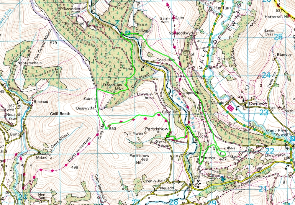
9 Miles, 2,300 Feet of Ascent
It was fairly cloudy when we set off from home and the start of the walk in Grwyne Fawr Valley was in dark woodland. As we set off through the forest there was a promising glimpse of blue above the canopy.

Sun through the canopy
I’m not a great fan of forestry plantation roads but this one was fine with shafts of bright sunlight to lead the way.

Pastures in the forest
We headed onwards through the trees to emerge at the buildings of Ffordd Las Fawr. James had mentioned that he stayed here with friends when he did the walk before and how fantastic a spot it was. It’s no longer occupied and boarded up but the charm of the place is still apparent. There was a sign at the bottom of the hill noting a planning application so hopefully someone will restore it to greater glory. For now I took some photos for James, dreamt of turning this into my home and moved on.

Ffordd Las Fawr

Ffordd Las Fawr

Ffordd Las Fawr
From here the route climbs steeply through the woods and boy are the trees dense here. It was quite extraordinarily dark. I was expecting fire-breathing dragons and ogres to lurch from the depths and take us for a snack. No such excitement but it was strangely eerie and unsettling nonetheless. I tried a few photos but it was just too dark. After passing through a couple of clearings we emerged on the ridge into bright blue skies and blazing sunshine, it felt almost springlike.

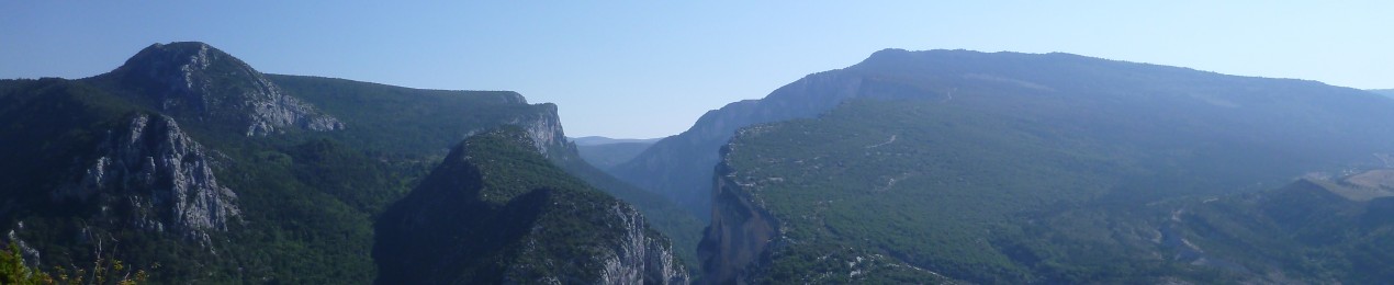
Black Mountains from the ridge to Crug Mawr

Across the Vale of Ewyas to Hatterrall Hill
All around was the desolation of cleared forest. I guess it will take generations, if ever, for the landscape to recover its former state. I’m really not a fan of the blankets of coniferous plantations that cloak large portions of our uplands but they seem to be clearing now slowly but surely. We turned and headed for Crug Mawr at the southern end of the long ridge that stretches from Waun Fach, the highest of the Black Mountains. As we approached the top the wind kicked in and it suddenly turned from spring back to winter. It was bitingly cold.

TJS on Crug Mawr summit
The views more than compensated. All a round was blue sky and dark brown heather and bracken clad mountains. The summit is only 550m but it feels higher such is the feast of views spread out beneath.

Waun Fach from Crug Mawr

Sugar Loaf from Crug Mawr
I could have lingered longer but the cold forced us to move off and down the faint path along the slopes towards Partrishow . After a rather brief and cold lunch spot (it was one of those days when the wind searches you out wherever you sit) we headed down to the valley bottom again past the beautiful stone church of Partrishow.

Partrishow Church

Sugar Loaf
Time to head back up again and we followed a succession of green lanes and paths, twisting and turning this way and that until we finally emerged onto the open slopes of the Twyn y Gaer Hill Fort.
The top was surprisingly crowded with several families playing army and rolling about on the slopes of the old grass ramparts. It had clouded over a bit but the wind had dropped and we found a quiet sheltered spot behind a gorse bush for a snack. The long ridge stretched out before us towards Bal Mawr and the sun returned as we rested. The views were as excellent as I hoped.

Black Mountains from Twyn y Gaer Hill Fort,

Hatterrall Hill from Twyn y Gaer Hill Fort
I was pleased to add another mental chapter to my book “Small Hills with Disproportionately Great Views” I checked the map and realised it was quite a stroll back to the car so we pressed on down the easy angled slopes and along the ridge. The first part was enclosed by forest and walls but soon opened out to a narrowing grassy ridge with superb views out to the NE over the Vale of Ewyas.

Twyn y Gaer Hill Fort
As the path climbs the ridge towards Bal Mawr, our route took us off on a quite splendid path traversing back above the Grwyne Fawr Valley. The skies had cleared again and we were treated to more spring-like sunshine and golden hillsides.

Black Mountains and the Grwyne Fawr Valley

TJS on the final leg
It really was a terrific walk this one and one I’d be glad to repeat in stages as a post work walk. All that remained was to follow the path down to the forests and back to the car. Quite a long day in the end at just over 9 miles, both me and TJS were a little weary by the end, both ready for our Sunday Roast when we got home.


What you need is a decent camera with ultra wide lens to take advantage of the panorama 😉
LikeLike
You’re a bad influence on me, first Quinn now you, no wonder I’m broke.
I’m showing promise though?
LikeLike
all good mate… all good 🙂
LikeLike
I’ll be browsing later – drop you a few questions for some help. After the last couple of days I need some retail therapy
LikeLike
spend… spend… spend :-0
LikeLike
Do I detect a bit of an Elbow theme going on lately? Thought you didn’t like them?
But blue sky and sunshine – looks idyllic, like springtime instead of winter……….
LikeLike
They’re growing on me, still a bit hit and miss but they make for great melodic soundtracks. Boy does that blue sky feel an awfully long way away tonight 🙂
LikeLike
another great trip! lovely landscapes that makes jealous feeling to readers, at least me 🙂
LikeLike
Thanks for the kind words, glad you enjoyed the photos
LikeLike
I always love the colors in your photos!
LikeLike
Thanks Bob, I do my best! It’s all back and white at home at the moment – we have 3 inches of snow and the coldest March weekend for a few years
LikeLike
Good to see some photos of Ffordd Las there Andy. I managed a few visits whilst still in the hands of a friends uncle. The best being a few days all on my own in the depths of winter. It’s got some atmosphere about it when alone I can tell you. Also a good test of your driving skills in a campervan to get there! On one trip we had to abandon the van half way up the track http://backpackingbongos.files.wordpress.com/2010/01/p1000374.jpg
I know that it sold for over £300,000, someone obviously having a bit of cash to splash!
Cracking area and one I need to return to for a backpack. Love the hill fort for its views, a summer bivi spot I reckon?
LikeLike
It has so much potential and looked lovely on that sunny morning. The last bit of the track was just soggy bog – not sure if it’s deteriorated along with the house but you’d need a serious 4WD to get to the front door. Hopefully it will be restored to glory, what a place to live!
I have grand plans for the spring and summer (should they ever arrive), lots of local short overnight backpacks so I can get my fix and still do the family stuff, stacks of spots I’ve found if you can carry a bit of water with you. Planning and packing for a backpack to the Western Highlands over Easter, should be interesting!
LikeLike
It was always a bit of a challenge getting a vehicle to the front door, especially the bridleway section after leaving the forestry track. Always managed it though, the final steep section needing a bit of welly to get a normal car up! I would imagine that after all the rain over the last year it may have got worse though. I liked staying there as walking into the main room was like going back 100 years, no mod cons and a fire place big enough to lay down in. Gas lights etc. Lovely it was.
Where are you off to over Easter? I have plans to backpack in the Monadhliath next weekend, with plan B being a low level route on the other side of the Coran ferry if conditions rubbish.
LikeLike
Spookily enough the plan is go to the other side of the Corran Ferry! Glen Scaddle in fact. My Corbett bagging mate has some missing up there but it does look a terrific spot. Easy walk in as it’s only 6ish miles and 100m above sea level but the tops will be in full winter conditions, ice axe and crampons needed. Need to check the weather though, it’s a total wipeout up there at the minute and the long range forecast doesn’t look promising. Adventures to be had somewhere though!
LikeLike
Really?! My plan was to park up at Inverscaddle bay and walk the full length of Cona Glen, cross a low pass to near Glenfinnan and then walk the length of Loch Shiel to Polloch. Up to Resourie bothy then bash down Glen Scaddle back to the car. All low level so no ice axe and crampons not needed. Just don’t want it pishing down with rain though!
I think that the west has had pretty good weather compared to the east plus the snow does not stick around as long.
LikeLike
Sounds like a great lower level walk but quite a distance. Far too lazy for that. Just walk to the far end of Glen Scaddle, spend 3 nights there, bag some Corbetts or smaller hills (or shiver in the tent) and then walk back out again. Resourie used to be a bugger to find in the forest but I think they have cleared it now. Nice bothy though. If you see a dark green Lightwave tent at the head of Glen Scaddle then drop in for a cuppa if we’re in residence 🙂
LikeLike
I need to get this lardy arse in shape for the TGO Challenge otherwise I would find a beach nearby to camp next to for the weekend! If I go we may have to arrange a quick rendevous.
LikeLike
Be great to meet up if things work out. Drop me mail if you like. I think you can see my mail address from when I comment on your blog but if not:
andymadleyhotmaildotcodotuk. I’ll do the same if my plans change and I bail out
LikeLike
Will do as soon as me plans are together.
LikeLike
Ah, the magical Vale of Ewyas! Are there no ends to its delights? Looks like a cracking walk. Good to see that you and D are getting out frequently. Has he taken over the navigating yet?
Is there nothing much to see in terms of remains of the hill fort?
LikeLike
When we use a guidebook he navigates but I take care of the map. I’m planning on getting him to plan routes from the map and navigate properly. There are a few ditches on the fort and you can clearly see it’s form from a distance but it’s more a nice viewpoint than anything else. Good one for a post-work walk when spring arrives…..
LikeLike
Or an evening jaunt, later in the year, in May perhaps?
LikeLike
…and a plan was formed. I have loads of those sorts of walks – I think an overnight would be a good idea if you can find a sleeping bag
LikeLike
Now that is tempting. Time to do some more research.
LikeLike